- Texas State Highway 168
Infobox TX State Highway
type=State
route=168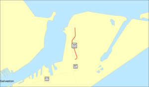
length_mi=0.873
length_ref=TxDOT|SH|168|accessdate=2008-03-15]
length_round=3
formed=1986
dir1=South
dir2=North
from=jct|state=TX|SH|87 in Galveston
junction=
to=Coast Guard Station Galveston
previous_type=State
previous_route=167
next_type=State
next_route=169State Highway 168 or SH 168 is a short state highway in the
U.S. state ofTexas connecting the naval installation at Galveston to SH 87. At convert|0.87|mi long, it is the shortest main state highway in Texas.History
SH 168 was previously designated as a possible route extending from Campbellton northeast through Floresville ending near Stockdale. By 1939, the section from Floresville to Stockdale was transferred to SH 97, while the section from Campbellton to Floresville remains unbuilt to this day.Fact|date=February 2008 The current routing in Galveston was designated in October 1985.
Route description
SH 168 runs north from SH 87 approximately convert|0.87|mi to the Naval installation in Galveston. The highway runs parallel to the east of SH 87 near where SH 87 crosses
Galveston Bay via theBolivar Free Ferry .Junction List
References

Wikimedia Foundation. 2010.