- Øvrebø og Hægeland
-
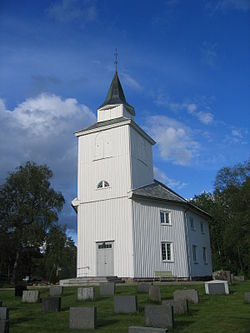
Øvrebø og Hægeland herred — Former Municipality — Hægeland Church Coordinates: 58°17′26″N 07°46′39″E / 58.29056°N 7.7775°ECoordinates: 58°17′26″N 07°46′39″E / 58.29056°N 7.7775°E Country Norway County Vest-Agder District Sørlandet Municipality ID NO-1016 Adm. Center Øvrebø Created from Øvrebø in 1865 Split into Øvrebø and Hægeland in 1896 Øvrebø og Hægeland is a former municipality in Vest-Agder county in Norway. It is located in the northern part of the present-day municipality of Vennesla, just to the west of the Otra river.
Contents
Name
The municipality is a combination of the names of two parishes: Øvrebø and Hægeland. Øvrebø is named after the old Øvrebø farm (Old Norse: Øfribœr), since the first church was built there. The first part of the name means "upper" and second part of the name is identical with the word bœr which means "farm" and it is cognate with the Dutch language word "boer" which means "farmer". The name therefore means "the upper farm".[1]
Hægeland is named after the old Hægeland farm (Old Norse: Helgaland). The first element of the name means "holy" (Old Norse: heilagr and Norwegian: hellig) and the last element (Old Norse: land) is identical with the word land which means "land". This area was important to ancient Norse pagan worship.[2][3]
History
The municipality of Øvrebø og Hægeland was established in 1865 when the old municipality of Øvrebø was divided into Vennesla (population: 1,103) and Øvrebø og Hægeland (population: 1,829). The municipality existed until 1 July 1896, when it was split to create two municipalities: Øvrebø (population: 888) and Hægeland (population: 843). These two municipalities later merged into Vennesla.[4]
References
- ^ Rygh, Oluf (1912) (in Norwegian). Norske gaardnavne: Lister og Mandals amt (9 ed.). Kristiania, Norge: W. C. Fabritius & sønners bogtrikkeri. pp. 36. http://www.dokpro.uio.no/perl/navnegransking/rygh_ng/rygh_bla.prl?enhid=142011&avid=32103.
- ^ "Hægeland" (in Norwegian). Store norske leksikon. http://www.snl.no/Hægeland. Retrieved 2009-10-29.
- ^ Rygh, Oluf (1912) (in Norwegian). Norske gaardnavne: Lister og Mandals amt (9 ed.). Kristiania, Norge: W. C. Fabritius & sønners bogtrikkeri. pp. 34. http://www.dokpro.uio.no/perl/navnegransking/rygh_ng/rygh_bla.prl?enhid=141914&avid=32079.
- ^ Jukvam, Dag (1999) (in Norwegian) (PDF). Historisk oversikt over endringer i kommune- og fylkesinndelingen. Statistisk sentralbyrå. http://www.ssb.no/emner/00/90/rapp_9913/rapp_9913.pdf.
External links
Categories:
Wikimedia Foundation. 2010.

