Dissected plateau

Dissected plateau
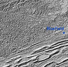
Shaded relief map of Cumberland Plateau and Ridge and Valley Appalachians on the Virginia/West Virginia border

A dissected plateau is a plateau area that has been severely eroded so that the relief is sharp. Such an area may be referred to as mountainous, but dissected plateaus are distinguishable from orogenic mountain belts by the lack of folding, metamorphism, extensive faulting, or magmatic activity that accompanies orogeny.

The Allegheny Plateau,[1] the Cumberland Plateau,[2] the Ozark Plateau,[3] the Catskill Mountains,[4] and the Blue Mountains are examples of dissected plateaus formed after regional uplift. These older uplifts have been eroded by creeks and rivers to develop steep relief not immediately distinguishable from mountains. Many areas of the Allegheny Plateau and the Cumberland Plateau, which are at the western edge of the Appalachian Mountains of eastern North America, are called "mountains" but are actually dissected plateaus. One can stand on the top of one of these high "mountains" and note that all the other tops are nearly the same height, which represents the original elevation profile of the plain before uplift, and thereafter the subsequent weather erosion.

A dissected plateau may also be formed, or created, usually on a comparatively small scale, by the levelling of terrain by planing and deposition beneath an ice sheet or perhaps, an ice cap. Subsequently, during the same or a later glacial, the margins of the glacial till plain are removed by glaciers, leaving the plateau into which erosion by water incises valleys. Such a plateau may be level or gently sloping but may be distinguished by the till caps on its hills. Glacial till is still widely known in Britain by the older name of boulder clay.

Dissected volcanic plateaus include the Pajarito Plateau in New Mexico, on the skirt of the enormous Valles Caldera.[5] Isolated portions of this plateau are known as mesas, and long, connected portions are known as potreros.

See also

References

  1. ^ Jones, Stephen B.1; Saviello, Thomas BA Field Guide to Site Quality for the Allegheny Hardwood Region Northern Journal of Applied Forestry, Volume 8, Number 1, 1 March 1991 , pp. 3-8(6)
  2. ^ PHYSIOGRAPHY Wayne L. Newell
  3. ^ The Ozarks Chronicle
  4. ^ Catskill Center
  5. ^ Mathien, Frances Joan; Steen, Charlie R.; Allen, Craig D. (1993). The Pajarito Plateau: A bibliography. Professional Paper. Southwest Cultural Resources Center. http://www.cr.nps.gov/history/online_books/band/pajarito_plateau.pdf. 

Wikimedia Foundation. 2010.

Игры ⚽ Поможем сделать НИР

Look at other dictionaries:

  • dissected plateau —    A land area (landscape) produced by significant stream erosion and incision of a plateau such that only a small part of the plateau surface is at or near the original summit level. Much of the area occurs as hillslopes, or if incision is… …   Glossary of landform and geologic terms

  • Plateau (disambiguation) — Plateau has several meanings:*In geology or earth science, a plateau is an area of relative low relief (i.e., relatively flat) at an important altitude, usually attributed to tectonic uplift or by sediment accumulation. If the uplift was recent,… …   Wikipedia

  • dissected — [dis sekt′id, ] also [dī sekt′id, dī′sekt΄id] adj. 1. cut up into parts 2. Bot. consisting of many lobes or segments, as some leaves 3. Geol. cut by erosion into valleys and hills [a dissected plateau] …   English World dictionary

  • Plateau — For other meanings, see Plateau (disambiguation). Island in the Sky, Canyonlands National Park …   Wikipedia

  • dissected — adjective Date: 1652 1. cut deeply into fine lobes < a dissected leaf > 2. divided into hills and ridges (as by gorges) < a dissected plateau > …   New Collegiate Dictionary

  • Plateau du Columbia (écorégion) — Écorégion de niveau III du Nord Ouest Pacifique. L écorégion du Plateau du Columbia (10) est délimitée par les écorégions des Cascades orientales (9), des montagnes Bleues (11), des Northern Rockies (15), du Batholite d Idaho (16) et des North… …   Wikipédia en Français

  • Dissected Till Plains — Continental U.S physiographic regions. Region 12e identifies the Dissected Till Plains. The Dissected Till Plains are physiographic sections of the Central Lowlands province, which in turn is part of the Interior Plains physiographic division of… …   Wikipedia

  • Plateau de Millevaches — The Plateau de Millevaches (in Occitan Replanat de Miuvachas) is an upland area in the Limousin région of France. It covers approximately 3,500 km² and crosses the boundaries of three French départements : the Corrèze, the Creuse and the Haute… …   Wikipedia

  • Plateau (Known space) — Infobox fictional planet name=Plateau imagesize= caption= universe=Known Space locations=Mount Lookitthat people=Matthew Keller, Laney Mattson, Polly Tournquist, Millard Parlette, Jesus Pietro Castro, Arthur Treginnis races=Humans creator=Larry… …   Wikipedia

  • dissected — /di sek tid, duy /, adj. 1. Bot. deeply divided into numerous segments, as a leaf. 2. Phys. Geog. separated, by erosion, into many closely spaced crevices or gorges, as the surface of a plateau. [1625 35; DISSECT + ED2] * * * …   Universalium

Share the article and excerpts

Direct link
Do a right-click on the link above
and select “Copy Link”