- Eastern Sierra Regional Airport
Infobox Airport
name = Eastern Sierra Regional Airport
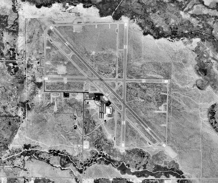
image-width = 250
caption =USGS aerial photo as of 3 August 1999
IATA = BIH
ICAO = KBIH
FAA = BIH
type = Public
owner = City of Los Angeles, Dept. of Public Works
operator =
city-served =Bishop, California
location =
elevation-f = 4,124
elevation-m = 1,257
coordinates = coord|37|22|23|N|118|21|49|W|region:US_type:airport
website =
r1-number = 7/25
r1-length-f = 5,566
r1-length-m = 1,697
r1-surface = Asphalt
r2-number = 12/30
r2-length-f = 7,498
r2-length-m = 2,285
r2-surface = Asphalt
r3-number = 16/34
r3-length-f = 5,600
r3-length-m = 1,707
r3-surface = Asphalt
h1-number = H1
h1-length-f = 40
h1-length-m = 12
h1-surface = Asphalt
h2-number = H2
h2-length-f = 100
h2-length-m = 30
h2-surface = Asphalt
stat-year = 2006
stat1-header = Aircraft operations
stat1-data = 26,000
stat2-header = Based aircraft
stat2-data = 64
footnotes = Source:Federal Aviation Administration FAA-airport|ID=BIH|use=PU|own=PU|site=01327.*A, effective 2008-09-25.]Eastern Sierra Regional Airport airport codes|BIH|KBIH|BIH is a public-use
airport located twonautical mile s (4 km) east of thecentral business district of Bishop, in Inyo County,California ,United States . It is owned by the City ofLos Angeles , Department of Public Works.History
The airfield was opened in April 1940. During
World War II the airfield was known as Bishop Army Airfield and was used by theUnited States Army Air Forces Air Technical Service Command. With the end of the war, the base was declared excess to requirements and returned to civil control.Facilities and aircraft
Eastern Sierra Regional Airport covers an area of 830
acre s (336 ha) at anelevation of 4,124 feet (1,257 m) abovemean sea level . It has threeasphalt pavedrunway s: 7/25 is 5,566 by 100 feet (1,697 x 30 m); 12/30 is 7,498 by 100 feet (2,285 x 30 m); 16/34 is 5,600 by 100 feet (1,707 x 30 m). It also has twohelipad s: H1 is 40 by 40 feet (12 x 12 m) and H2 is 100 by 100 feet (30 x 30 m).For the 12-month period ending October 23, 2006, the airport had 26,000 aircraft operations, an average of 71 per day: 88%
general aviation and 12% military. At that time there were 64 aircraft based at this airport: 81% single-engine, 13% multi-engine, 2% jet and 5%glider .ee also
*
California World War II Army Airfields
*National Landmark of Soaring References
External links
*
*
Wikimedia Foundation. 2010.