- Moruya River
-
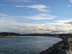 The Moruya River looking upstream from the breakwater on the northern head of the river
The Moruya River is in southern New South Wales, Australia. Its freshwater reaches are known as the Deua River.
The headwaters of the Moruya River rise as the Deua River south of Braidwood. The village of Araluen lies in the upper valley of the river, and the site of gold mining in the late nineteenth century.
The town of Moruya is located on the lower, estuarine reaches of the river, about 10 kilometers from the sea. The river was previously navigable by coastal shipping to Moruya and was serviced by the Illawarra Steam Navigation Company.
The Princes Highway crosses the river at Moruya. The first bridge across the Moruya River was erected in 1876. Due to frequent flooding new bridges were erected in 1900 and 1945 and, most recently, in 1966.[1]
The granite used to construct the facings of the pylons of the Sydney Harbour Bridge was quarried from the banks of the Moruya River.
The river has a bar at its confluence with the Tasman Sea.[2] The bar is dangerous to shipping and as a result of its hazards for smaller ships and because it prevented access by larger ones, the major settlement in the area was first developed at nearby Broulee. In 1841 a flood cleared the bar and the town of Moruya, now accessible to shipping, developed at the expense of the settlement at Broulee despite later recurring problems with the bar, not least as it was the easist point to access the rich Araluen goldfields from the 1850s.[1]
The Benandra, a wooden screw steamer operated by the Illawarra Steam Navigation Company to transport cargo, was lost on 25 March 1924 when it hit the sandspit near the bar. At least 1 person died.[3]
The bar is now managed in part by a rock breakwall on the northern side of the river.[citation needed]
At the mouth of the river is the town of Moruya Heads.
References
- ^ a b "Moruya". Travel (Sydney Morning Herald). 2004-02-08. http://www.smh.com.au/news/New-South-Wales/Moruya/2005/02/17/1108500197684.html. Retrieved 2007-01-11.
- ^ NSW Maritime List of Coastal Bars
- ^ "Benandra". Maritime Heritage Online. NSW Department of Planning - Heritage Office. http://maritime.heritage.nsw.gov.au/public/Site_View.cfm?Site_ID=1818. Retrieved 2006-12-18.
Categories:- Rivers of New South Wales
- South Coast, New South Wales
- New South Wales geography stubs

Wikimedia Foundation. 2010.