- Dowsborough
-
Dowsborough Camp Type Iron Age hill fort Location Country England County Somerset Nearest village Nether Stowey OS grid reference ST160391 Coordinates 51°08′44″N 3°12′05″W / 51.145434°N 3.201506°WCoordinates: 51°08′44″N 3°12′05″W / 51.145434°N 3.201506°W References Megalithic Portal Dowsborough Camp (or Danesborough or Dawesbury) is an Iron Age hill fort on the Quantock Hills near Nether Stowey in Somerset, England. It has been designated as a Scheduled Ancient Monument (No: 189456).[1]
Contents
Background
Further information: Hill fortHill forts developed in the Late Bronze and Early Iron Age, roughly the start of the first millennium BC.[2] The reason for their emergence in Britain, and their purpose, has been a subject of debate. It has been argued that they could have been military sites constructed in response to invasion from continental Europe, sites built by invaders, or a military reaction to social tensions caused by an increasing population and consequent pressure on agriculture. The dominant view since the 1960s has been that the increasing use of iron led to social changes in Britain. Deposits of iron ore were located in different places to the tin and copper ore necessary to make bronze, and as a result trading patterns shifted and the old elites lost their economic and social status. Power passed into the hands of a new group of people.[3] Archaeologist Barry Cunliffe believes that population increase still played a role and has stated "[the forts] provided defensive possibilities for the community at those times when the stress [of an increasing population] burst out into open warfare. But I wouldn't see them as having been built because there was a state of war. They would be functional as defensive strongholds when there were tensions and undoubtedly some of them were attacked and destroyed, but this was not the only, or even the most significant, factor in their construction".[4]
Situation
The site is at a height of 340 m on an easterly spur from the main Quantock ridge, with views north to the Bristol Channel, and east over the valley of the River Parrett.
The fort has an oval shape, with a single rampart and ditch (univallate) following the contours of the hill top, enclosing an area of 2.7 ha.[5] The main entrance is to the east, towards Nether Stowey, with a simpler opening to the north-west, aligned with a ridgeway leading down to Holford. The Lady's Fountain springs are in the combe to the west. A col to the south connects the hill to the main Stowey ridge, where a linear earthwork known as Dead Woman's Ditch cuts across the spur. This additional rampart would have provided an extra line of defence against attack from the main Quantock ridge to the west, and it could have been a tribal boundary.
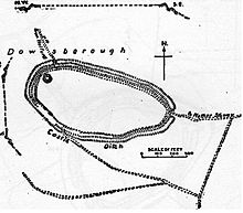 Earthworks at Dowsborough hill fort
Saxon era
In Saxon times, King Alfred's military road, the Herepath, ran up from Combwich, Cannington (a possible site of the Battle of Cynwit) and Over Stowey, along the present course of the Stowey road, across Dead Woman's Ditch to Crowcombe Park Gate, south along the main ridge of the Quantocks to Triscombe Stone, then west across the valley to the Brendon Hills and Exmoor. The road connected a series of forts and lookout posts, which allowed Alfred's armies to move along the coast to cover Viking movements at sea and forestall any raids ashore. The path from Dowsborough to the Herepath is called Great Bear Path, and this is taken to be a corruption of Great Herepath, which suggests that Dowsborough could have been a Saxon lookout over the Bristol Channel.
See also
- Ruborough
- Trendle Ring
- Plainsfield Camp
- Herepath
- List of hill forts and ancient settlements in Somerset
References
- ^ "Dowsborough Camp". National Monuments Record. English Heritage. http://www.pastscape.org.uk/hob.aspx?hob_id=189456. Retrieved 23 March 2011.
- ^ Payne, Andrew; Corney, Mark; Cunliffe, Barry (2007), The Wessex Hillforts Project: Extensive Survey of Hillfort Interiors in Central Southern England, English Heritage, p. 1, ISBN 9781873592854, http://www.english-heritage.org.uk/server/show/ConWebDoc.10744
- ^ Sharples, Niall M (1991), English Heritage Book of Maiden Castle, London: B. T. Batsford, pp. 71–72, ISBN 0-7134-6083-0
- ^ Time Team: Swords, skulls and strongholds, Channel 4, 2008-05-19, http://www.channel4.com/history/microsites/T/timeteam/2008/swords/swords-found.html, retrieved 16 September 2009
- ^ "Dowsborough hillfort, Holford". Somerset Historic Environment Record. Somerset County Council. http://webapp1.somerset.gov.uk/her/details.asp?prn=33306. Retrieved 28 December 2010.
- Dumnonia and the Valley of the Parret, Rev. W.H.P. Greswell (1922)
- A Field Guide to Somerset Archaeology, Lesley and Roy Adkins (1992) ISBN 0-946159-94-7
- Somerset Historic Environment Record Dowsborough Camp (Site no. 33306)
Categories:- Hill forts in Somerset
- Scheduled Ancient Monuments in Somerset

Wikimedia Foundation. 2010.