Bommenede

Bommenede
Bommenede (center, in green) in 1650.

Bommenede or Bommenee is a former island, village, and municipality in the Netherlands, located about 5 km east of the city of Brouwershaven.

The village of Bommenede

Bommenede was founded in the early 12th centure by monks of the Cistercian monastery of Ter Duinen in Flanders. It was located on one of the four islands that later joined up to form the current island of Schouwen-Duiveland. The name was first mentioned in 1165, as insula Bomne. The island was a part of Holland, because the boundary between Holland and Zeeland lay in the Sonnemere, the water south of Bommenede.

According to the 19th century historian A.J. van der Aa[1], John of Bavaria ordered the construction of dykes around the island in 1412, creating the polder of Bommenede. The village of Bommenede was listed in 1153 as property of the Cistercian monastery of Ter Duinen in Flanders. The village survived two floods in 1530 and 1532 and a fire in 1540. In 1570, Bommenede and the neighbouring polder "Kijkuit" were flooded during the All Saints' Flood.

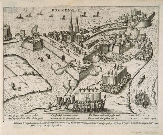
The siege of Bommenede (1575).

Because of the strategic location of the village, a defensive wall was built around it in 1574. The following year, the Spanish commander Mondragon besieged it for 20 days, and shot the village to pieces. At the end of the siege, no more than 20 healthy men survived in the village.[1]

The village was flooded again on January 26, 1682. The destruction was so great, that the Estates of Holland decided not to rebuild the village, and the last inhabitants left in 1684. Some remains of the village (now sometimes referred to as Oud-Bommenede) remained visible for years. Nowadays, there is still some overgrown debris in the waters of the Grevelingen.

Nieuw-Bommenede

Part of the former island was reclaimed from the sea in 1701. In the southern part of the new polder, a new hamlet grew: Nieuw-Bommenede. In the middle of the 19th century, it had about 410 inhabitants.[1]

The municipality of Bommenede in 1866.

Bommenede was a separate heerlijkheid, and later a separate municipality (also called "Bommenede en Bloois"), until it was merged with the municipality of Zonnemaire on January 4, 1866.[2]

References

  1. ^ a b c Abraham Jacob van der Aa, "Aardrijkskundig woordenboek der Nederlanden", vol. 2 (B), 1840, p. 561.
  2. ^ Ad van der Meer and Onno Boonstra, Repertorium van Nederlandse gemeenten, KNAW, 2006.


Coordinates: 51°44′N 3°56′E / 51.733°N 3.933°E / 51.733; 3.933


Wikimedia Foundation. 2010.

Игры ⚽ Нужна курсовая?

Look at other dictionaries:

  • Bommenede — 51°44′4″N 3°58′44″E / 51.73444, 3.97889 …   Wikipédia en Français

  • Liste aller niederländischen Gemeinden A–L — In diese Liste werden alle Gemeinden, die auf dem Gebiet der jetzigen Niederlande bestehen oder bestanden haben, aufgenommen. Die Liste beginnt im Jahr 1805/10. Vor 1830 können die Angaben unvollständig sein. Kleinere Grenzkorrekturen oder… …   Deutsch Wikipedia

  • Liste aller niederländischen Gemeinden M–Z — In diese Liste werden alle Gemeinden, die auf dem Gebiet der jetzigen Niederlande bestehen oder bestanden haben, aufgenommen. Die Liste beginnt im Jahr 1805/10. Vor 1830 können die Angaben unvollständig sein. Kleinere Grenzkorrekturen oder… …   Deutsch Wikipedia

  • Liste der ehemaligen Gemeinden in Zeeland — Hierunter folgt eine Liste der ehemaligen seeländischen Gemeinden. Wenn das Gebiet einer aufgehobenen Gemeinde über mehrere Gemeinden verteilt worden ist, ist das Großteil der erstgenannten Gemeinde hinzugefügt. Grenzkorrekturen zwischen… …   Deutsch Wikipedia

  • Liste der ehemaligen Gemeinden in der Provinz Zeeland — Hierunter folgt eine Liste der ehemaligen seeländischen Gemeinden. Wenn das Gebiet einer aufgehobenen Gemeinde über mehrere Gemeinden verteilt worden ist, ist das Großteil der erstgenannten Gemeinde hinzugefügt. Grenzkorrekturen zwischen… …   Deutsch Wikipedia

  • Anciennes Communes De La Zélande — En 1812, la province néerlandaise de la Zélande comptait 143 communes. Depuis 2003, il n y en a plus que 13. Voici les étapes principales des fusions : 1813 1816 : Suppression des plus petites communes des îles zélandaises 1961 :… …   Wikipédia en Français

  • Anciennes communes de la Zelande — Anciennes communes de la Zélande En 1812, la province néerlandaise de la Zélande comptait 143 communes. Depuis 2003, il n y en a plus que 13. Voici les étapes principales des fusions : 1813 1816 : Suppression des plus petites communes… …   Wikipédia en Français

  • Anciennes communes de la Zélande — En 1812, la province néerlandaise de la Zélande comptait 143 communes. Depuis 2003, il n y en a plus que 13. Voici les étapes principales des fusions : 1813 1816 : Suppression des plus petites communes des îles zélandaises 1961 :… …   Wikipédia en Français

  • Anciennes communes de la zélande — En 1812, la province néerlandaise de la Zélande comptait 143 communes. Depuis 2003, il n y en a plus que 13. Voici les étapes principales des fusions : 1813 1816 : Suppression des plus petites communes des îles zélandaises 1961 :… …   Wikipédia en Français

  • Zonnemaire — 51° 42′ 45″ N 3° 57′ 03″ E / 51.7125, 3.95083333 …   Wikipédia en Français

Share the article and excerpts

Direct link
Do a right-click on the link above
and select “Copy Link”