Myślenice County

Myślenice County
Myślenice County
Powiat myślenicki
—  County  —

Flag

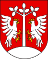
Coat of arms
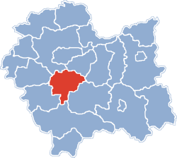
Location within the voivodeship
Coordinates (Myślenice): 49°50′N 19°56′E / 49.833°N 19.933°E / 49.833; 19.933Coordinates: 49°50′N 19°56′E / 49.833°N 19.933°E / 49.833; 19.933
Country  Poland
Voivodeship Lesser Poland
Seat Myślenice
Gminas
Area
 – Total 673.3 km2 (260 sq mi)
Population (2006)
 – Total 116,793
 – Density 173.5/km2 (449.3/sq mi)
 – Urban 30,403
 – Rural 86,390
Car plates KMY
Website http://www.powiat-myslenice.pl

Myślenice County (Polish: powiat myślenicki) is a unit of territorial administration and local government (powiat) in Lesser Poland Voivodeship, southern Poland. It came into being on January 1, 1999, as a result of the Polish local government reforms passed in 1998. Its administrative seat and largest town is Myślenice, which lies 26 kilometres (16 mi) south of the regional capital Kraków. The county also contains the towns of Sułkowice, lying 10 km (6 mi) west of Myślenice, and Dobczyce, 15 km (9 mi) north-east of Myślenice.

The county covers an area of 673.3 square kilometres (260.0 sq mi). As of 2006 its total population is 116,793, out of which the population of Myślenice is 18,070, that of Sułkowice is 6,305, that of Dobczyce is 6,028, and the rural population is 86,390.

Neighbouring counties

Myślenice County is bordered by Kraków County and Wieliczka County to the north, Bochnia County and Limanowa County to the east, Nowy Targ County to the south, and Sucha County and Wadowice County to the west.

Administrative division

The county is subdivided into nine gminas (three urban-rural and six rural). These are listed in the following table, in descending order of population.

Gmina Type Area
(km²)
Population
(2006)
Seat
Gmina Myślenice urban-rural 153.7 40,783 Myślenice
Gmina Dobczyce urban-rural 66.6 13,941 Dobczyce
Gmina Sułkowice urban-rural 60.5 13,784 Sułkowice
Gmina Pcim rural 88.6 10,327 Pcim
Gmina Lubień rural 75.0 9,294 Lubień
Gmina Tokarnia rural 68.9 8,072 Tokarnia
Gmina Siepraw rural 31.9 7,809 Siepraw
Gmina Wiśniowa rural 67.1 6,833 Wiśniowa
Gmina Raciechowice rural 61.0 5,950 Raciechowice

References


Wikimedia Foundation. 2010.

Игры ⚽ Нужен реферат?

Look at other dictionaries:

  • Nowa Wieś, Myślenice County — For other places with the same name, see Nowa Wieś (disambiguation). Nowa Wieś   Village   …   Wikipedia

  • Łęki, Myślenice County — Infobox Settlement name = Łęki settlement type = Village total type = image shield = subdivision type = Country subdivision name = POL subdivision type1 = Voivodeship subdivision name1 = Lesser Poland subdivision type2 = County subdivision name2 …   Wikipedia

  • Zawada, Myślenice County — Infobox Settlement name = Zawada settlement type = Village total type = image shield = subdivision type = Country subdivision name = POL subdivision type1 = Voivodeship subdivision name1 = Lesser Poland subdivision type2 = County subdivision… …   Wikipedia

  • Dziekanowice, Myślenice County — Infobox Settlement name = Dziekanowice settlement type = Village total type = image shield = subdivision type = Country subdivision name = POL subdivision type1 = Voivodeship subdivision name1 = Lesser Poland subdivision type2 = County… …   Wikipedia

  • Krzeczów, Myślenice County — Infobox Settlement name = Krzeczów settlement type = Village total type = image shield = subdivision type = Country subdivision name = POL subdivision type1 = Voivodeship subdivision name1 = Lesser Poland subdivision type2 = County subdivision… …   Wikipedia

  • Stróża, Myślenice County — Infobox Settlement name = Stróża settlement type = Village total type = image shield = subdivision type = Country subdivision name = POL subdivision type1 = Voivodeship subdivision name1 = Lesser Poland subdivision type2 = County subdivision… …   Wikipedia

  • Bieńkowice, Myślenice County — Infobox Settlement name = Bieńkowice settlement type = Village total type = image shield = subdivision type = Country subdivision name = POL subdivision type1 = Voivodeship subdivision name1 = Lesser Poland subdivision type2 = County subdivision… …   Wikipedia

  • Brzezowa, Myślenice County — Infobox Settlement name = Brzezowa settlement type = Village total type = image shield = subdivision type = Country subdivision name = POL subdivision type1 = Voivodeship subdivision name1 = Lesser Poland subdivision type2 = County subdivision… …   Wikipedia

  • Skrzynka, Myślenice County — Infobox Settlement name = Skrzynka settlement type = Village total type = image shield = subdivision type = Country subdivision name = POL subdivision type1 = Voivodeship subdivision name1 = Lesser Poland subdivision type2 = County subdivision… …   Wikipedia

  • Gruszów, Myślenice County — Infobox Settlement name = Gruszów settlement type = Village total type = image shield = subdivision type = Country subdivision name = POL subdivision type1 = Voivodeship subdivision name1 = Lesser Poland subdivision type2 = County subdivision… …   Wikipedia

Share the article and excerpts

Direct link
Do a right-click on the link above
and select “Copy Link”