- Groton-New London Airport
Infobox Airport
name = Groton-New London Airport
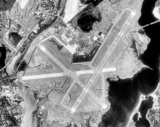
image-width = 250
caption = 12 April 1991
IATA = GON
ICAO = KGON
FAA = GON
type = Public
owner = Connecticut Department of Transportation (ConnDOT)
operator =
city-served =
location =Groton, Connecticut
elevation-f = 9
elevation-m = 3
coordinates = coord|41|19|48|N|072|02|42|W|type:airport
website = [http://grotonnewlondonairport.com/ GrotonNewLondonAirport.com]
r1-number = 5/23
r1-length-f = 5,000
r1-length-m = 1,524
r1-surface = Asphalt
r2-number = 15/33
r2-length-f = 4,000
r2-length-m = 1,219
r2-surface = Asphalt
stat-year = 2006
stat1-header = Aircraft operations
stat1-data = 52,394
stat2-header = Based aircraft
stat2-data = 69
footnotes = Source:Federal Aviation Administration FAA-airport|ID=GON|use=PU|own=PU|site=02823.*A, effective 2007-07-05]Groton-New London Airport Airport codes|GON|KGON|GON is a state-owned public-use
airport located three miles (5 km) southeast of thecentral business district of Groton, a town in New London County,Connecticut ,United States . It serves the southeastern Connecticut region, including the shoreline localities of Groton, New London, and Mystic.Over the years, and usually no more than one at a time, various domestic airlines served the airport, including
Pan Am Clipper Connection and Pilgrim Airlines. Scheduled commercial passenger service was limited to small turboprop aircraft such asde Havilland Dash 8 andBeechcraft 1900 . Eventually the airport became no longer a profitable destination, andUSAirways Express , the last major carrier to serve the airport, terminated its GON-PHL service in 2004. Two charter airlines, however, do continue to shuttle passengers to and from the airport.The airport has also been used by several presidents speaking at the commencement of the nearby
US Coast Guard Academy . The most recent visit was by President Bush onMay 23 ,2007 .Facilities and aircraft
Groton-New London Airport covers an area of 489
acre s (198 ha) which contains twoasphalt pavedrunway s: 5/23 measuring 5,000 x 150 ft (1,524 x 46 m) and 15/33 measuring 4,000 x 100 ft (1,219 x 30 m).For the 12-month period ending June 30, 2006, the airport had 52,394 aircraft operations, an average of 143 per day: 87%
general aviation , 8% military, 5%air taxi and <1% scheduled commercial. There are 69 aircraft based at this airport: 33% single engine, 25% multi-engine, 14% jet aircraft, 26%helicopter s and 1% military.Charter airlines
*
Columbia Air Service
*Lanmar Aviation ee also
*
Connecticut World War II Army Airfields References
External links
* [http://www.grotonnewlondonairport.com/ Groton-New London Airport] (official site)
*WikiMapia|41.3301|-72.0451|13
*FAA-diagram|05049
*US-airport|GON
Wikimedia Foundation. 2010.