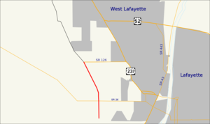
Indiana State Road 126 — Infobox road state=IN type=IN route=126 alternate name= maint=INDOT length mi=1.1 length round=2 length ref= [http://illi indi.com/EndsPage.php?id=1126 section=1 Indiana Highway Ends SR 126] ] established= direction a=West starting terminus=… … Wikipedia
Indiana State Road 545 — Infobox road state=IN type=IN route=545 alternate name= length mi= length round= length ref= established= direction a=West starting terminus= junction= direction b=East ending terminus= counties= previous type=IN previous route=526 next type=IN… … Wikipedia
Indiana State Road 524 — Infobox road state=IN type=IN route=524 alternate name= length mi=2 length round=1 length ref= [http://illi indi.com/EndsPage.php?id=1524 section=1 Indiana Highway Ends SR 524] ] established= direction a=West starting terminus= junction=… … Wikipedia
List of State Roads in Indiana — State Roads in the US state of Indiana are numbered rationally: in general, odd one digit and two digit highways are north south highways, numbers increasing toward the west; even one digit and two digit highways are east west highways, numbers… … Wikipedia
Road — This article is about a route, thoroughfare or way that supports travel by a means of conveyance. For a place outside a harbor where a ship can lie at anchor, see Roadstead. For public roads, see Highway. For other routes, see thoroughfare. For… … Wikipedia
Dubois County, Indiana — The Dubois County courthouse in Jasper, Indiana … Wikipedia
State highways in New Jersey — Standard route signage in New Jersey Highway names Interstates: Interstate X (I X) … Wikipedia
Gibson County, Indiana — Infobox U.S. County county = Gibson County state = Indiana founded year = 1813 from Knox County founded date = April 1 seat = Princeton largest city = Princeton (10,270) Fort Branch (3,800) Oakland City (3,102) city type = area total sq mi = 526… … Wikipedia
National Register of Historic Places listings in St. Joseph County, Indiana — Location of St. Joseph County in Indiana This is a list of the National Register of Historic Places listings in St. Joseph County, Indiana. This is intended to be a complete list of the properties and districts on the National Register of… … Wikipedia
Milwaukee Road Bunkhouse — U.S. National Register of Historic Places … Wikipedia