- Mount Wellington, New Zealand
-
Mt Wellington Basic information Local authority Auckland Facilities Train station(s) Panmure Train Station Surrounds North Ellerslie, St. John's Park East Tamaki River, Pakuranga South Westfield West Penrose Mount Wellington 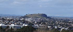
Mount WellingtonElevation 135 m (443 ft) Location Location Auckland, North Island, New Zealand Range Auckland Volcanic Field Coordinates 36°55′S 174°49′E / 36.917°S 174.817°E Climbing First ascent Unknown Easiest route Hike Mount Wellington is a peak and a suburb in Auckland City, New Zealand
Contents
The volcano
Mount Wellington is a 137 metre volcanic peak located in the Auckland volcanic field of Auckland, New Zealand. It is the youngest onshore volcano of the Auckland volcanic field, having been formed by an eruption around 10,000 years ago. It is the largest of Auckland's scoria cones.[1]Mt Wellington is not expected to erupt again.
The suburb
The suburb surrounding the peak is also called Mount Wellington, and is located 10 kilometres southeast of the city centre. It is surrounded by the suburbs of Tamaki, Panmure, Penrose, and Ellerslie, and by the Tamaki River. State secondary schools serving the area include St Peter's College and Selwyn College.
History of Mount Wellington
Named by colonists after the Duke of Wellington, the native Māori people called it Maungarei and used it for centuries as a pā or hill fort.
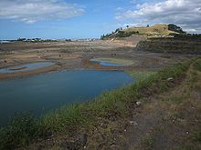 Mount Wellington rises beyond the redeveloped quarry to its north
Much of the old lava flow surrounding the mountain has been quarried for industrial aggregates, and the large quarry to the north of the mountain produced 7% of New Zealand's roading aggregate.[1] The quarry has now closed and is being redeveloped for housing. The volcanic scoria cone is of the greatest geological and archaeological interest however.
Education
- Bailey Road School is a state, coeducational full primary (years 1-8) school with a roll of 418 and a decile rating of 3.[2]
- Stanhope Road School is a state, coeducational full primary (years 1-8) school with a roll of 495 and a decile rating of 4. It was established in 1958.[3]
- Sylvia Park School is a state, coeducational full primary (years 1-8) school with a roll of 248 and a decile rating of 2.[4]
See also
References
- ^ a b "Volcanoes of Auckland: Mt Wellington". Auckland Regional Council. http://www.arc.govt.nz/environment/volcanoes-of-auckland/mt-wellington.cfm. Retrieved 2009-March-05.
- ^ Te Kete Ipurangi schools database: Bailey Road School
- ^ Te Kete Ipurangi schools database: Stanhope Road School
- ^ Te Kete Ipurangi schools database: Sylvia Park School
- Volcanoes of Auckland: The Essential guide - Hayward, B.W., Murdoch, G., Maitland, G.; Auckland University Press, 2011.
External links
Coordinates: 36°53′31″S 174°50′48″E / 36.891909°S 174.846554°E
Categories:- Cinder cones
- Suburbs of Auckland
- Auckland Volcanic Field
- Mountains of New Zealand
- Auckland Region geography stubs


Wikimedia Foundation. 2010.