Chattooga Ranger District
- Chattooga Ranger District
-
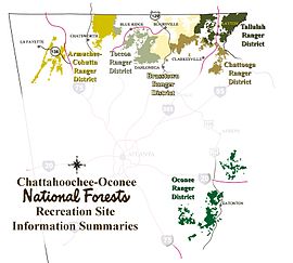
Map showing the ranger districts of the Chattahoochee National Forest
The Chattooga Ranger District is one of the five ranger districts of the Chattahoochee National Forest. The district is spread through portions of Banks, Habersham, Lumpkin, Stephens, Towns, Union and White Counties in Georgia. Some of the features within the borders of the district are the Soque River, Tray Mountain and the Tray Mountain Wilderness.
The current headquarters for the Chattooga Ranger District is located in Clarkesville, Georgia. However, on March 9, 2006, the District Ranger announced that the Tallulah Ranger District and the Chattooga Ranger District will be combined and a new office will be opened in a central location between Clayton, Georgia and Clarkesville.[1] The location (in Rabun County, Georgia along U.S. 441, south of Clayton and north of Tallulah Falls) is expected to be completed in phases over a five year period and will include a new District Office, a work center, and a helibase.[2]
References
- ^ March 9, 2006 press release
- ^ July 3, 2006 press release
External links
Categories:
- Protected areas of Banks County, Georgia
- Protected areas of Habersham County, Georgia
- Protected areas of Lumpkin County, Georgia
- Protected areas of Stephens County, Georgia
- Protected areas of Towns County, Georgia
- Protected areas of Union County, Georgia
- Protected areas of White County, Georgia
- Chattahoochee-Oconee National Forest
Wikimedia Foundation.
2010.
Look at other dictionaries:
Tallulah Ranger District — The Tallulah Ranger District is one of the five ranger districts of the Chattahoochee National Forest. The largest portion of the district is located in Rabun County, Georgia, which contains nearly convert|149000|acre|km2. A portion of the… … Wikipedia
Ranger — was a gamekeeper in the 14th century England, though the meaning evolved to mean a soldier who ranges over a region to protect the area or enforce the law ( range meaning travel around an area ). In Britain, the term has been associated with a… … Wikipedia
Armuchee-Cohutta Ranger District — The Armuchee Cohutta Ranger District is one of the five ranger districts of the Chattahoochee National Forest. Armuchee is thought to be derived from the Cherokee word for hominy, to be derived from the Choctaw word alurnushi , meaning hiding… … Wikipedia
Chattooga River — This article is about the river forming the boundary between Georgia and South Carolina; for the river with the same name in western Georgia and eastern Alabama, see Chattooga River (Alabama Georgia). Chattooga River near Dick s Creek Falls The… … Wikipedia
Chattahoochee-Oconee National Forest — Herbst im Chattahoochee National Forest Der Chattahoochee Oconee National Forest in Nordgeorgia umfasst zwei Nationalforste, den Oconee National Forest und den Chattahoochee National Forest. Die Gesamtfläche des Chattahoochee Oconee National… … Deutsch Wikipedia
Tray Mountain Wilderness — The Tray Mountain Wilderness was designated in 1986 and currently consists of convert|9702|acre|km2. The Wilderness is located within the borders of the Chattahoochee National Forest in Habersham, Towns and White counties, Georgia and is managed… … Wikipedia
Soque River — The Soque River and the Soque River Watershed are located entirely within the county boundaries of Habersham County in northeast Georgia. The Soque is a tributary of the Chattahoochee River. Portions of the river run along State Route 197. [cite… … Wikipedia
Horsetrough Falls — are located on one of the flanks of Horsetrough Mountain in Union County, Georgia. This 70 foot waterfall is located on a creek that is part of the headwaters of the Chattahoochee River and is in the Mark Trail Wilderness. There is an observation … Wikipedia
Chattahoochee-Oconee National Forest — Fall in the Chattahoochee National Forest The Chattahoochee Oconee National Forest in northern Georgia comprises two United States National Forests, the Oconee National Forest and Chattahoochee National Forest. The combined total area of the… … Wikipedia
Sumter National Forest — The Sumter National Forest is one of two forests in South Carolina that are managed together by the United States Forest Service, the other being the Francis Marion National Forest. The Sumter National Forest consists of 370,442 acres (1,499 km²) … Wikipedia

