- Council House, Bristol
-
Council House 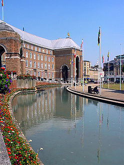
The Council House, Bristol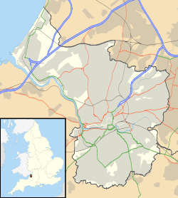
 Location within Bristol
General information Town or city Bristol Country England Coordinates 51°27′09″N 2°36′11″W / 51.45263°N 2.60295°W Construction started 1938 Completed 1956 Design and construction Client Bristol city council Architect Vincent Harris The Council House has been the seat of local government in Bristol, England since 1956. It is situated on College Green, opposite the Cathedral and at the foot of Park Street in Bristol city centre (grid reference ST582728). Throughout its history it has been home to Bristol city council.
It was designed in the 1930s but built after World War II. The architect was Vincent Harris.
Contents
Building
It is a grade II* listed building. The concrete frame is clad with very wide, thin bricks, with Portland stone dressings and a leaded hipped roof in a Neo-Georgian style. The steep and high roof with gilded unicorns to the corners of the end blocks.[1]
The foundation stone for The Council House was laid in 1938 and the building was opened by the Queen in 1956. The ceremonial entrance overlooks the moat and leads into the reception hall which is lined with local Doulting stone and paved with black and white Italian marble. It also features a blue and gold wall clock, encircled by the signs of the zodiac and equipped with its own wind indicator. The Conference Hall is the largest room in the building. The names of all Mayors and Lord Mayors of Bristol since 1216 are cut into the stone walls. The walls of the Lord Mayor’s Reception Room are panelled in English Walnut and there is a colourful frieze displaying the heraldry of the Bristol trade guilds, and, in gold leaf, the names of famous Bristolians.[2]
Ceilings
The ceiling of the council chamber was designed by John Armstrong (1893–1973) and depicts buildings in Bristol at the edge and the centre details sailing ships from different periods of Bristol History. The four corners show the allegorical figures of Enterprise, Wisdom, Industry and Navigation.[3] The ceiling in the Conference Room is by Sir Walter Thomas Monnington (1902–1976) on the theme of molecular and atomic fusion.[4]
Environmental aspects
Refurbishment of the electrical and heating systems have incorporated the use of rainwater recycling for flushing toilets and an air-conditioning system that will discharge excess heat into the surrounding water filled moat rather than expelling it into the atmosphere.[5] There are now plans to double-glaze the entire building some time in 2008.
Popular culture
One of the building's gilded unicorns appears in the opening credits of the first series of popular television show, Skins.[6]
References
- ^ "Council House and attached railings and piers". Images of England. http://www.imagesofengland.org.uk/details/default.aspx?id=379313. Retrieved 2006-08-21.
- ^ "The Council House". Bristol City Council. http://www.bristol.gov.uk/ccm/content/Leisure-Culture/venues/conference-hire.en?page=7. Retrieved 19 December 2010.
- ^ "ceiling of Bristol council chambers". The Art fund. http://www.artfund.org/artwork/9341/original-design-for-the-ceiling-of. Retrieved 2006-08-21.
- ^ "Council House and attached railings and piers". Images of England. http://www.imagesofengland.org.uk/details/default.aspx?id=379313. Retrieved 2006-08-21.
- ^ "Council House, Bristol City Council". Ridge. Archived from the original on 2006-07-19. http://web.archive.org/web/20060719234206/http://www.ridge.co.uk/projects/local_authorities/bristol_city_council.aspx. Retrieved 2006-08-21.
- ^ "Unicorn of Bristol's Council House in opening credits of Skins". Picasaweb. http://picasaweb.google.com/skinsonline/SkinsOnlineFanblog#5084159620475198162. Retrieved 2009-02-22.
Categories:- City and town halls in England
- Grade II* listed buildings in Bristol
- Buildings and structures completed in 1956
- Buildings and structures in Bristol


Wikimedia Foundation. 2010.