- Beechborough-Greenbrook
Infobox City
official_name = Beechborough-Greenbrook
subdivision_type2 = Country
subdivision_name2 =Canada
subdivision_type1 = Province
subdivision_name1 =Ontario
subdivision_type = City
subdivision_name =Toronto 
mapsize=150px
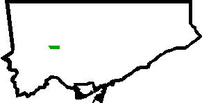
map_caption=Location of Beechborough-Greenbrook within Toronto
Beechborough-Greenbrook is a
neighbourhood in the city ofToronto ,Canada . It is located in the former City of York and is bordered by Greenbrook Drive to the north, theCanadian National Railway rail line to the east,Eglinton Avenue West to the south and another CN rail line to the west. TheYork Civic Centre , which housed York's municipal offices prior to the amalgamation of Metropolitan Toronto in 1998, is located in Beechborough-Greenbrook.The neighbourhood has a large number of Roman Catholics who are Italian and Portuguese by descent. The neighbourhood is very diverse; however, and there are also above average numbers of
Baptist s, Buddhists and Christians. Latin Americans, Blacks and Southeast Asians are also represented in above average numbers in this neighbourhood (source: statscan 2001).Nearly two-thirds of the neighbourhood's population resides in rental units, many of them in low-rise apartment buildings. Due to the low income in the area, there is an above average number of renters and rental units.
Toronto Neighbourhood Geography
North = Brookhaven-Amesbury
East =Briar Hill-Belgravia
South =Keelesdale-Eglinton West
West =Mount Dennis
Center = Beechborough-GreenbrookExternal links
* [http://www.toronto.ca/demographics/cns_profiles/cns112.htm City of Toronto - Beechborough-Greenbrook Neighbourhood Profile]
Wikimedia Foundation. 2010.
