- Mary Island Light
-
Mary Island Light 
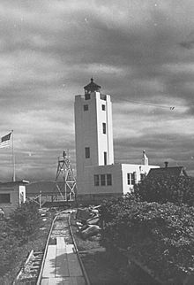
Mary Island Light in 1937 Location Mary Island, Revillagigedo Channel, Alaska Coordinates 55°05′56″N 131°10′54″W / 55.09889°N 131.18167°W Year first lit 1903 Automated 1969 Foundation Concrete Construction Reinforced concrete Tower shape White art deco square tower Height 61 ft (76 feet above sea level) Original lens Fourth order Fresnel lens, 1903 Range 6 nm Characteristic Flashing white 6s, Obscured from 341° to 150°. Admiralty number G6006 ARLHS number ALK-009 USCG number 6-21940 The Mary Island Light Station is a lighthouse located on the northeastern part of Mary Island in southeastern Alaska, USA.
History
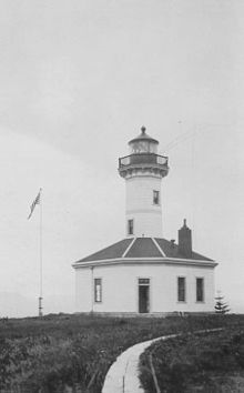
Mary Island Light Station was opened in 1903, and was one of a series of staffed lights established by the U.S. Government to guide ships through the treacherous waters of Southeast Alaska's Inside Passage. In 1937, a concrete lighthouse and fog signal building replaced the original wood tower. Situated behind the light were two lightkeeper houses which housed the Coast Guard Lightkeepers. One of the houses burned down in 1965(?); the other house was moved off the island to nearby Ketchikan, Alaska.
In 1969 the station was automated and the radio beacon was removed. No other buildings and structures at the station stand today, other than an outhouse.
Actually, the northern of the two keepers dwellings was moved in 1964 while I was there. The southern dwelling was used by the 4 man crew until the station was decommissioned in 1969, and in 1970 the dwelling was moved.
External links
- "Historic Light Station Information and Photography: Alaska". United States Coast Guard Historian's Office. http://www.uscg.mil/history/weblighthouses/LHAK.asp.
- Lighthouse Friends — Mary Island Lighthouse
- Rowlett, Russ. "Lighthouses of Alaska". The Lighthouse Directory. University of North Carolina at Chapel Hill. http://www.unc.edu/~rowlett/lighthouse/ak.htm.
 Categories:
- 1903 architecture
- 1937 architecture
- Lighthouses in Alaska
- Buildings and structures in Ketchikan Gateway Borough, Alaska
Wikimedia Foundation. 2010.

