- Northway Airport
-
Northway Airport 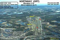
IATA: ORT – ICAO: PAOR – FAA LID: ORT Summary Airport type Public Owner Alaska DOT&PF - Northern Region Serves Northway, Alaska Elevation AMSL 1,715 ft / 523 m Coordinates 62°57′40″N 141°55′41″W / 62.96111°N 141.92806°WCoordinates: 62°57′40″N 141°55′41″W / 62.96111°N 141.92806°W Map Location of airport in Alaska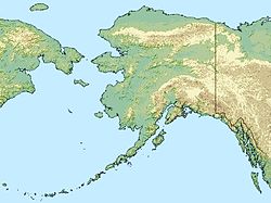
 ORT
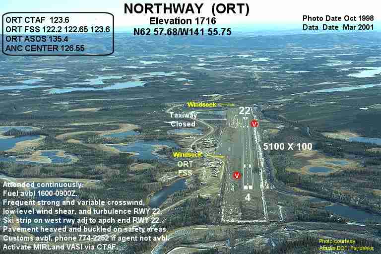
ORTRunways Direction Length Surface ft m 5/23 5,100 1,554 Asphalt Statistics (2005) Aircraft operations 15,800 Source: Federal Aviation Administration[1] Northway Airport (IATA: ORT, ICAO: PAOR, FAA LID: ORT) is a state-owned public-use airport located in Northway,[1] in the Southeast Fairbanks Census Area of the U.S. state of Alaska.
As per Federal Aviation Administration records, this airport had 55 commercial passenger boardings (enplanements) in calendar year 2010, an increase of 511% from the 9 enplanements in 2009.[2] It is included in the FAA's National Plan of Integrated Airport Systems for 2011–2015[3] which categorized it as a general aviation facility.
Contents
Facilities and aircraft
Northway Airport covers an area of 1,150 acres (465 ha) at an elevation of 1,715 feet (523 m) above mean sea level. It has one runway designated 5/23 with an asphalt surface measuring 5,100 by 100 feet (1,554 x 30 m).[1]
For the 12-month period ending December 31, 2005, the airport had 15,800 aircraft operations, an average of 43 per day: 73% general aviation, 25% air taxi, and 2% military.[1]
Airline and scheduled destination
- 40-Mile Air (Tok)[4]
References
- ^ a b c d FAA Airport Master Record for ORT (Form 5010 PDF). Federal Aviation Administration. Effective 25 August 2011.
- ^ "Passenger Boarding (Enplanement) Data for CY 2010 (final)". Federal Aviation Administration. 4 October 2011. http://www.faa.gov/airports/planning_capacity/passenger_allcargo_stats/passenger/index.cfm?year=2010.
- ^ "2011–2015 NPIAS Report, Appendix A (PDF, 2.03 MB)". 2011–2015 National Plan of Integrated Airport Systems. Federal Aviation Administration. 4 October 2010. http://www.faa.gov/airports/planning_capacity/npias/reports/media/2011/npias_2011_appA.pdf.
- ^ "2011 Schedule and Prices". 40-Mile Air. http://www.fortymileair.com/scheduled_destinations.htm. Retrieved 15 October 2011.
External links
- FAA Alaska airport diagram (GIF)
- Topographic map as of 1 July 1955 from USGS The National Map
- FAA Terminal Procedures for ORT, effective 20 October 2011
- Resources for this airport:
- AirNav airport information for PAOR
- ASN accident history for ORT
- FlightAware airport information and live flight tracker for PAOR
- NOAA/NWS latest weather observations for PAOR
- SkyVector aeronautical chart for ORT
Categories:- Airports in the Southeast Fairbanks Census Area, Alaska
- USAAF Air Transport Command Airfields - Alaska

Wikimedia Foundation. 2010.