- Diakovce
-
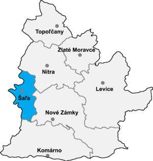 Location of Šaľa District in the Nitra region
Diakovce (Hungarian: Deáki) is an old village and municipality in Šaľa District, in the Nitra Region of southwest Slovakia.
Contents
History
In historical records the village was first mentioned in 1002 meaning that it is one of the oldest recorded villages in Slovakia. In 1001, Stephen I of Hungary deployed Benedictines here. From that time, the area was the property of the abbey of Pannonhalma. In 1228 a twin-towered Romanesque cathedral, the oldest monument in Slovakia, was built.
Geography
The village lies at an altitude of 118 metres and covers an area of 26.28 km². It has a population of about 2235 people.
Ethnicity
The village is about 72% Magyar and 28% Slovak.
Facilities
The village has a public library, a gym a swimming pool and a football pitch.
External links
Šaľa
Diakovce · Dlhá nad Váhom · Hájske · Horná Kráľová · Kráľová nad Váhom · Močenok · Neded · Selice · Tešedíkovo · Trnovec nad Váhom · Vlčany · Žihárec
Coordinates: 48°08′N 17°51′E / 48.133°N 17.85°E
Categories:- Villages and municipalities in Šaľa District
- Nitra Region geography stubs

Wikimedia Foundation. 2010.