- Districts of the British Virgin Islands
-
Contents
Administrative Districts

The five administrative subdivisions mentioned on some web pages may just be planning regions, without much administrative relevance:
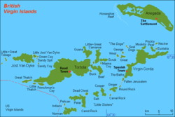
Subdivision Main town Area
km²Population
(estimate 2006)Anegada The Settlement 38.6 204 Jost Van Dyke Great Harbour (Jost Van Dyke) 8.3 176 Tortola Road Town 59.2 16,630 Virgin Gorda Spanish Town 21.2 3,063 Other Islands Great Harbour (Peter Island) 23.7 181 British Virgin Islands Road Town 151.0 20,253 The "Other Islands" are mainly the islands south of Tortola (separated from it by the Sir Francis Drake Channel and southwest of Virgin Gorda and detached Ginger Island, mainly Norman Island, Peter Island, Cooper Island and Salt Island. These islands are also known under the informal name Little Sisters or Southern Islands.
Civil Registry Districts
There are six Civil Registry Districts in the British Virgin Islands:
Civil Registry District Area District A Virgin Gorda District B Anegada District C East End (Tortola) District D Road Town (Tortola) District E West End (Tortola) District F Jost Van Dyke Civil Registry Districts C, D and E are subdivisions of the main island Tortola.
Electoral Districts
- By the Constitution and Elections Ordinance 1954, which establishes a new Legislative Council with an elected majority, the presidency is divided into five districts. Road Town District (area of the capital) sent two members to the legislative council, the other districts one each.
- A new constitution of 1967 provided for seven electoral districts, with one representative per district.
- In 1977, the number of electoral districts was augmented to nine. Each electoral district sends a member to the Legislative Council, which has 13 seats (including four at large members).
Electoral District Area First Electoral District West End, Carrott Bay (Tortola) Second Electoral District Meyers, Cane Garden Bay, Brewers Bay (Tortola) and Jost Van Dyke Third Electoral District Sea Cow's Bay and surroundings (Tortola) Fourth Electoral District Road Town and surroundings (Tortola) Fifth Electoral District Huntum's Ghut and Long Trench (Tortola) Sixth Electoral District Baugher's Bay and East Central Tortola Seventh Electoral District Long Look (Tortola) and Beef Island Eighth Electoral District East End, Greenland and Hope Estate (Tortola) Ninth Electoral District Virgin Gorda and Anegada External links
Categories:- Geography of the British Virgin Islands
- Politics of the British Virgin Islands
- Lists of country subdivisions
- Country subdivisions of the Americas
- British Virgin Islands-related lists

Wikimedia Foundation. 2010.