Stavroupoli, Xanthi

Stavroupoli, Xanthi
Stavroupoli
Σταυρούπολη
Location
Stavroupoli is located in Greece
{{{alt}}}
Stavroupoli
Coordinates 41°12′N 24°42′E / 41.2°N 24.7°E / 41.2; 24.7Coordinates: 41°12′N 24°42′E / 41.2°N 24.7°E / 41.2; 24.7
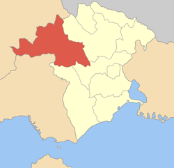
Government
Country: Greece
Region: East Macedonia and Thrace
Regional unit: Xanthi
Municipality: Xanthi
Population statistics (as of 2001)
Municipal unit
 - Population: 3,090
Other
Time zone: EET/EEST (UTC+2/3)
Auto: AH

Stavroupoli (Greek: Σταυρούπολη; Bulgarian: Кръстополе, Krastopole) is a village and a former municipality in the Xanthi peripheral unit, East Macedonia and Thrace, Greece. Since the 2011 local government reform it is part of the municipality Xanthi, of which it is a municipal unit.[1] Population 3,090 (2001). Stavroupoli and Nestos Valley (Greek: Κοιλάδα του Νέστου) including Nestos River Tempi (Greek: Τέμποι του Νέσου) is a popular tour region and vacation target in North Greece.

During the Bulgarian occupation of the region in World War II, the village was infamous as the location of the Krastopole or Enikyoy concentration camp where Bulgarian Communist Party workers and other left-wing enemies of the ruling regime were interned.[2]

The municipal unit Stavroupoli is subdivided into the communities Dafnonas, Gerakas, Karyofyto, Komnina, Neochori, Paschalia and Stavroupoli. The community Stavroupoli consists of the settlements Stavroupoli, Lykodromi, Kallithea and Margariti.

Notable people

External links

References

  1. ^ Kallikratis law Greece Ministry of Interior (Greek)
  2. ^ "Концентрационни лагери" (in Bulgarian). Българска енциклопедия А–Я. БАН, Труд, Сирма. 2002. ISBN 9548104083. 


Wikimedia Foundation. 2010.

Игры ⚽ Поможем решить контрольную работу

Look at other dictionaries:

  • Stavroupoli — (griechisch Σταυρούπολη; deutsche Übersetzung Kreuzstadt) ist der Name einer ehemaligen Gemeinde in der griechischen Verwaltungsregion Makedonien, siehe Stavroupoli (Thessaloniki) einer ehemaligen Gemeinde in der griechischen… …   Deutsch Wikipedia

  • Xanthi — Gemeinde Xanthi Δήμος Ξάνθης …   Deutsch Wikipedia

  • Xanthi (Präfektur) — Präfektur Xanthi (1944–2010) Νομός Ξάνθης Basisdaten (April 2010)[1] Staat …   Deutsch Wikipedia

  • Neochori, Xanthi — Neochori (Greek: Νεοχώρι) is a community in the municipality Xanthi in the Xanthi peripheral unit of Greece. It consists of the settlements Neochori, Ioniko, Kalyva, Kato Ioniko, Sidiropetra and Stavrochori. v …   Wikipedia

  • Nome de Xanthi — Nome de Xánthi Nome de Xánthi (el) Νομός Ξάνθης Administration Pays …   Wikipédia en Français

  • Nome de Xánthi — 41° 07′ 59″ N 24° 52′ 59″ E / 41.133, 24.883 …   Wikipédia en Français

  • List of settlements in the Xanthi prefecture — List of settlements in the Xanthi Prefecture, Greece. Contents 1 A–B 2 C–D 3 E–F 4 G–I 5 …   Wikipedia

  • Komnina (Xanthi), Greece — Komnina ( el. Κομνινά) is a settlement in the Xanthi prefecture of Greece (Longitude: 24° 43 38 E, Latitude: 41° 10 3 N). It is located 9 kilometers southeast of Stavroupoli and 31.5 kilometers from Xanthi. In 1981, the population of Komnina was… …   Wikipedia

  • Liste der Gemeinden Griechenlands — Griechenland gliedert sich seit dem 1. Januar 2011 in 13 Regionen und 325 Gemeinden. Durch das Kallikratis Gesetz wurden 240 Gemeinden durch Zusammenschluss zuvor bestehender kleinerer Gemeinden neu gebildet. Außer Kreta und Euböa sind die… …   Deutsch Wikipedia

  • Liste des communes de Grèce — Avertissement : les traductions du nom des différentes nouvelles entités administratives sont à prendre avec précaution, les dénominations n étant selon toute vraisemblance pas officiellement fixées en français. Voir l avertissement en tête… …   Wikipédia en Français

Share the article and excerpts

Direct link
Do a right-click on the link above
and select “Copy Link”