- Matsuyama Station (Ehime)
-
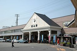
Matsuyama Station松山駅
Location Prefecture Ehime
(See other stations in Ehime)City Matsuyama History Year opened 1927 Rail services Station number(s) Y55, U00 Operator(s) JR Shikoku Line(s) Yosan Line Matsuyama Station (松山駅 Matsuyama-eki) is a JR Shikoku railway station on the Yosan Line located in Matsuyama, Ehime Prefecture, Japan.
The central station of the prefectural capital is on the Yosan line between Takamatsu, Kagawa and Uwajima, Ehime. Express trains head from Matsuyama to Okayama on Honshū, connecting with the Sanyō Shinkansen, and also to Takamatsu. The Okayama service is known as the Shiokaze and the Takamatsu service is known as the Ishizuchi (the name of the highest mountain on Shikoku). Southwards from Matsuyama, the Uwakai express train heads southwards to Uwajima. There are some through trains from Okayama and Takamatsu to Uwajima that stop at Matsuyama.
Local trains also head to destinations southwards and eastwards.
Iyo Railway has a tram stop named Matsuyama Ekimae in front of the station.
Contents
History
The station opened on April 3, 1927 when the San'yo Line (present-day Yosan Line) of Japanese Government Railways was extended from Iyo-Hōjō from Matsuyama.[1] By opening of Matsuyama Station, all prefectural capitals but Naha were connected by the government railways. The name Matsuyama Station was previously used by the terminal of Iyo Railway, which was renamed Matsuyama City Station in March 1927.
Layout
The station has two platforms: one is a side platform serving one track (No. 1) and is directly connected to the station building and the other is an island platform serving two tracks (Nos. 2 and 3). The two platforms are connected by an overbridge.[2]
Adjacent stations
« Service » Yosan Line Mitsuhama - Ichitsubo References
- ^ Ishino, Tetsu et al. (eds.) (1998) (in Japanese). Teishajō Hensen Daijiten - Kokutetsu JR Hen. Tokyo: JTB Corporation. p. 638, vol. II. ISBN 4533029809.
- ^ Station map by JR Shikoku
Coordinates: 33°50′23″N 132°45′04″E / 33.8398106°N 132.7510321°E

This Ehime Prefecture railroad station-related article is a stub. You can help Wikipedia by expanding it.
