- Oberstocken
-
Oberstocken Country Switzerland 
Canton Bern District Thun 46°42′N 7°33′E / 46.7°N 7.55°ECoordinates: 46°42′N 7°33′E / 46.7°N 7.55°E Population 285 (Dec 2010)[1] - Density 70 /km2 (180 /sq mi) Area 4.12 km2 (1.59 sq mi)[2] Elevation 691 m (2,267 ft) Postal code 3632 SFOS number 0765 Surrounded by Därstetten, Erlenbach im Simmental, Höfen, Niederstocken, Pohlern Website www.oberstocken.ch
SFSO statistics
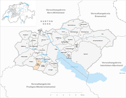
 OberstockenMap of Oberstocken
Oberstocken is a municipality in the administrative district of Thun in the canton of Bern in Switzerland.
Contents
History
Oberstocken is first mentioned in 1351 as Stogken.[3]
Demographics
Oberstocken has a population (as of 31 December 2010) of 285.[1] As of 2007[update], 3.1% of the population was made up of foreign nationals. Over the last 10 years the population has grown at a rate of 9.8%. Most of the population (as of 2000[update]) speaks German (99.2%), with most of the rest speaking French ( 0.4%).
In the 2007 election the most popular party was the SVP which received 48.6% of the vote. The next three most popular parties were the local small left-wing parties (15.9%), the SPS (10.6%) and the Green Party (9.1%).
The age distribution of the population (as of 2000[update]) is children and teenagers (0–19 years old) make up 25.9% of the population, while adults (20–64 years old) make up 60.5% and seniors (over 64 years old) make up 13.7%. In Oberstocken about 77.9% of the population (between age 25-64) have completed either non-mandatory upper secondary education or additional higher education (either university or a Fachhochschule).
Oberstocken has an unemployment rate of 2.38%. As of 2005[update], there were 4 people employed in the primary economic sector and about 2 businesses involved in this sector. 13 people are employed in the secondary sector and there are 5 businesses in this sector. 18 people are employed in the tertiary sector, with 6 businesses in this sector.[4] The historical population is given in the following table:[3]
year population 1764 120 1850 223 1900 179 1950 243 2000 263 Civil Defense
With its 290 inhabitants[5] this rural valley is designated as a civil defense evacuation site, with over 350 small bunkers. The main civil defense building is interimly used as a garage which houses 16 vehicles.[6]
Geography
Oberstocken has an area, as of 2009[update], of 4.12 square kilometers (1.59 sq mi). Of this area, 1.68 km2 (0.65 sq mi) or 40.8% is used for agricultural purposes, while 1.73 km2 (0.67 sq mi) or 42.0% is forested. Of the rest of the land, 0.16 km2 (0.062 sq mi) or 3.9% is settled (buildings or roads), 0.03 km2 (7.4 acres) or 0.7% is either rivers or lakes and 0.5 km2 (0.19 sq mi) or 12.1% is unproductive land.[7]
Of the built up area, housing and buildings made up 2.7% and transportation infrastructure made up 1.2%. Out of the forested land, 36.4% of the total land area is heavily forested and 2.7% is covered with orchards or small clusters of trees. Of the agricultural land, 4.6% is used for growing crops and 20.6% is pastures and 14.8% is used for alpine pastures. All the water in the municipality is in rivers and streams. Of the unproductive areas, 6.8% is unproductive vegetation and 5.3% is too rocky for vegetation.[7]
Oberstocken lies in a valley in the Bernse high country of the alps. The neighboring municipalities starting from the north in a clockwise direction are: Höfen, Niederstocken, Erlenbach im Simmental, Därstetten and Pohlern.
References
- ^ a b Swiss Federal Statistical Office - STAT-TAB, online database – Datenwürfel für Thema 01.2 - Bevölkerungsstand und -bewegung (German) accessed 29 September
- ^ Arealstatistik Standard - Gemeindedaten nach 4 Hauptbereichen
- ^ a b Oberstocken in German, French and Italian in the online Historical Dictionary of Switzerland.
- ^ Swiss Federal Statistical Office accessed 10-Jul-2009
- ^ Homepage de la commune d'Oberstocken
- ^ Willkommen in Oberstocken: Porträt unserer Gemeinde in German
- ^ a b Swiss Federal Statistical Office-Land Use Statistics 2009 data (German) accessed 25 March 2010
- This article incorporates information from the equivalent article on the German Wikipedia.
Amsoldingen | Blumenstein | Buchholterberg | Burgistein | Eriz | Fahrni | Forst-Längenbühl | Gurzelen | Heiligenschwendi | Heimberg | Hilterfingen | Höfen bei Thun | Homberg | Horrenbach-Buchen | Kienersrüti | Niederstocken | Oberhofen am Thunersee | Oberlangenegg | Oberstocken | Pohlern | Reutigen | Schwendibach | Seftigen | Sigriswil | Steffisburg | Teuffenthal | Thierachern | Thun | Uebeschi | Uetendorf | Unterlangenegg | Uttigen | Wachseldorn | Wattenwil | Zwieselberg
Canton of Bern | Districts of Canton Bern | Municipalities of the canton of Bern
 Categories:
- Municipalities of Bern
- Municipalities of Switzerland


Wikimedia Foundation. 2010.