- Ţinutul Crişuri
Infobox Settlement
official_name = Ţinutul Crişuri
other_name = Ţinutul Someş
settlement_type = Region ("Ţinut")
image_caption =
flag_link =
image_shield = Tinutul Somes.png
map_caption =
subdivision_type = Country
subdivision_name =
subdivision_type1 = Former counties included
subdivision_name1 =Bihor County ,Cluj County ,Maramureş County ,Sălaj County ,Satu Mare County ,Someş County ,Năsăud County
subdivision_type2 = Historic region
subdivision_name2 =Transylvania (Maramureş,Crişana )
subdivision_type3 = Capital city ("Reşedinţă de ţinut")
subdivision_name3 = Cluj
government_footnotes =
government_type = Rezident Regal
leader_party =
leader_title =
leader_name =
leader_title1 =
leader_name1 =
established_title = Established
established_date = The administrative reform of 1938
established_title2 = Cesed to exist
established_date2 = Territorial loss and new administrative law (30 August 1940)
area_magnitude =
area_total_km2 = 33385
area_land_km2 =
area_water_km2 =
area_total_sq_mi =
area_land_sq_mi =
area_water_sq_mi =
area_water_percent =
area_urban_km2 =
area_urban_sq_mi =
area_metro_km2 =
area_metro_sq_mi =
elevation_footnotes =
elevation_m =
elevation_ft =
latd =
latm =
lats =
latNS =
longd =
longm =
longs =
longEW =
population_as_of = 1938 (?)
population_footnotes =
population_total = 2.143.453
population_density_km2 =
population_density_sq_mi =
population_metro =
population_density_metro_km2 =
population_density_metro_sq_mi =
population_urban =
population_density_urban_km2 =
population_density_urban_sq_mi =
population_note =
timezone = EET
utc_offset = +2
timezone_DST = EEST
utc_offset_DST = +3
postal_code_type =
postal_code =
area_code =
blank_name =
blank_info =
footnotes =
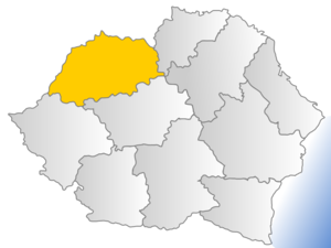
website =Ţinutul Crişuri (or "Ţinutul Someş") was one of the ten
Romania n "ţinuturi" founded in1938 , after King Carol II initiated an institutional reform by modifying the 1923 Constitution and the law of territorial administration. It comprised part ofTransylvania , and included the entire regions ofCrişana and Maramureş. It was named after the rivers Crişul Alb, Crişul Negru, and Crişul Repede; its capital was the city of Cluj.Coat of Arms
The Coat of Arms is composed of seven sinister bends, four of
gules and three ofazure , representing the former seven counties ("judeţe") of theGreater Romania (71 in total in 1938) it included. Over the mirror bends there is a sableaurochs head (in reference toVoivode Dragoş of Maramureş, and to the symbol ofMoldavia - "seeFlag and coat of arms of Moldavia ").Former counties incorporated
After the 1938 "Administrative and Constitutional Reform", the older 71 counties lost their authority. The list below just helps drawing the map.
*Bihor County
*Cluj County
*Maramureş County
*Sălaj County
*Satu Mare County
*Someş County
*Turda County In 1939
Turda County was ceded to "Ţinutul Mureş " in exchange forNăsăud County .ee also
*
Nord-Vest (development region)
*History of Romania External links
* [http://www.eliznik.org.uk/RomaniaEthno/politicalmap/Romania_1939.gifMap]

Wikimedia Foundation. 2010.