- Donegall Road
-
The Donegall Road (Irish: Bóthar Dhún na nGall) runs from Shaftesbury Square in Belfast city centre to the Falls Road in west Belfast. It is bisected by the Westlink, and the largest part of the road, prior to the Westlink junction, is predominantly unionist. The latter part is predominantly nationalist.
Contents
History
The road is named after the Marquess of Donegall, a prominent family in the Peerage of Ireland which have given their name to a number of locations in Belfast.
During the Troubles the Donegall Road was the scene of a number of attacks by paramilitaries from both sides. Eastwood's Garage was the scene of one of the explosions that took place on Bloody Friday in 1972 as part of a series of Provisional Irish Republican Army bomb attacks on a single day.[1] The site is still occupied by a garage.
On 7 September 1993 Stephen McKeag and two other volunteers in C-Company of the Ulster Defence Association's West Belfast Brigade entered a hairdresser's shop on the upper Donegall Road and shot the proprietor Sean Hughes dead. Although brought to trial, McKeag – known as "Top Gun" – was not convicted after eyewitness testimony did not stand up to scrutiny.[2]
Features
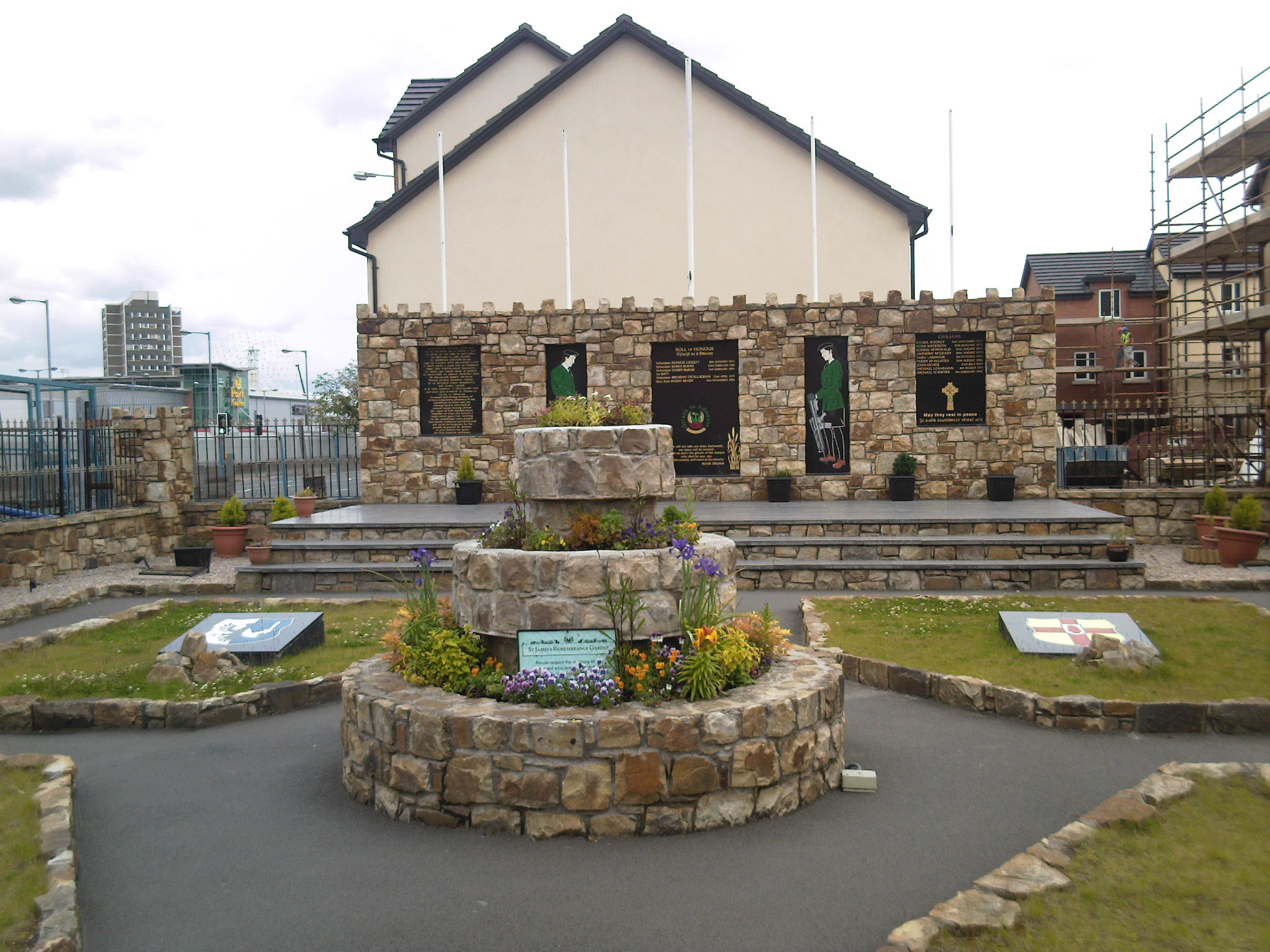
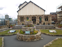 Republican memorial garden in St James's district of Donegall Road
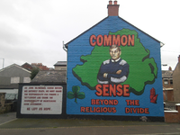
The eastern side the road and the streets leading from it, are predominantly Protestant and include the well-known Sandy Row and The Village areas. Most of the housing is of the 'two up, two down' (many of them converted) red-bricked terraced variety. The area is mostly working class, but has become a cachement area for student rental accommodation due to its close proximity to Queen's University. Across Broadway in West Belfast the demographics change as the road forms the southern border of the almost exclusively Roman Catholic St. James area. Located where this section of the road meets the Broadway intersection is the Park Centre, a shopping centre built on the former site of Celtic Park, the home of the now defunct Belfast Celtic.[3]
The road provides access to the Belfast City Hospital and the City Hospital railway station. Travelling outwards from the city centre also takes one to the Broadway entrance of the Royal Victoria Hospital. The road gets particularly congested at peak times. It is bordered by the Lisburn Road, the "Golden Mile" and Sandy Row
Famous people
The Donegall Road is the birthplace of popular singer Ruby Murray. Murray's ties to the area are now commemorated by a photographic montage on the side of the Road's Credit Union.[4]
Snooker player Alex 'Hurricane' Higgins also grew up on the road, having been born on Abingdon Drive.[5] He was a regular visitor to the local snooker hall, the Jampot Club, before he went on to win the World Snooker Championship for the first time in 1972.[6] Like Murray, Higgins is also commemorated by a piece of public art on the road.[7]
Politics
For representation on Belfast City Council the Donegall Road is split between the Balmoral District Electoral Area, currently represented by Claire Hanna and Bernie Kelly of Social Democratic and Labour Party (SDLP), Tom Ekin of the Alliance Party of Northern Ireland (APNI), Ruth Patterson of the Democratic Unionist Party (DUP), Máirtín Ó Muilleoir of Sinn Féin and Bob Stoker of the Ulster Unionist Party (UUP)[8], and the Laganbank District Electoral Area, an area currently represented by Kate Mullen and Pat McCarthy of the SDLP, Catherine Curran of the APNI, Deirdre Hargey of Sinn Féin and Christopher Stalford of the DUP.[9] It is part of the Belfast South constituency for the House of Commons, with Alasdair McDonnell of the SDLP serving as MP, as well as the Belfast South constituency of the Northern Ireland Assembly which is represented by Conall McDevitt and Alasdair McDonnell of the SDLP, Anna Lo of the APNI, Michael McGimpsey of the Ulster Unionist Party, Alex Maskey of Sinn Fein and Jimmy Spratt of the DUP.
References
- ^ CAIN Note: the site mistakenly refers to the attack as taking place in Donegall Street, an unrelated area of Belfast City Centre
- ^ Henry McDonald & Jim Cusack, UDA - Inside the Heart of Loyalist Terror, Penguin Ireland, 2004, p. 2
- ^ Park Centre
- ^ Greater Village Regeneration Trust
- ^ Alex Higgins' funeral taking place in Belfast
- ^ Obituary: Alex Higgins - Two-times world snooker champion whose style of play and wild ways electrified the sport
- ^ Belfast says goodbye to Alex Higgins, a troubled and ungovernable man who came to define this volatile city...
- ^ District electoral area - Balmoral
- ^ District electoral area - Laganbank
Roads and motorways in Northern Ireland Motorways 
Main 'A' roads Others Crumlin Road · Donegall Square · Donegall Road · Falls Road · Glenshane Pass · Lisburn Road · Malone Road · Ormeau Road · Shankill Road · Stranmillis Road · WestlinkCategories:- Streets in Belfast
- Roads in Northern Ireland
- United Kingdom road stubs


Wikimedia Foundation. 2010.