Naasa Hablood

Naasa Hablood

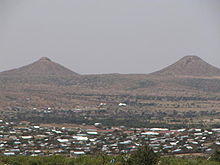
Naasa Hablood (Somali: Naaso Hablood) (literally, Girl's Breasts) are twin hills situated on the outskirts of the city of Hargeisa in northeastern Somaliland. Since their discovery, the Naasa Hablood have become a key tourist attraction and a national landmark. The hills, which are made of granite and sand, are shaped like two, huge pyramids.

History

Naasa Hablood

It is believed that the Naasa Hablood were formed after earthquakes struck the region several million years ago.[citation needed] When Somalis ruled the area now known as Somalia thousands of years ago, Ancient Egyptians came to their lands (which were then known as the Land of Punt). The Ancient Egyptians presented the locals with gifts and, in exchange, they received frankincense and myrrh. ==See also==

  • Breast shaped hills

External links

Coordinates: 9°36′N 44°07′E / 9.6°N 44.117°E / 9.6; 44.117


Wikimedia Foundation. 2010.

Игры ⚽ Поможем решить контрольную работу

Look at other dictionaries:

  • Naasa-Hablood — Ansicht von Hargeysa auf die Naasa Hablood Hügel Die Naasa Hablood Hügel Die Naasa Hablood Hügel (Somali für „Mädchenbrüste“) sind zwei nebeneinander gelegene Hügel nordöstlich von Harg …   Deutsch Wikipedia

  • Naasa Hablood — Ansicht von Hargeysa auf die Naasa Hablood Hügel Die Na …   Deutsch Wikipedia

  • Naasa-Hablood-Hügel — Ansicht von Hargeysa auf die Naasa Hablood Hügel Die Naasa Hablood Hügel Die Naasa Hablood Hügel (Somali für „Mädchenbrüste“) sind zwei nebeneinander gelegene Hügel nordöstlich von Harg …   Deutsch Wikipedia

  • Naasa Hablood-Hügel — Ansicht von Hargeysa auf die Naasa Hablood Hügel Die Naasa Hablood Hügel Die Naasa Hablood Hügel (Somali für „Mädchenbrüste“) sind zwei nebeneinander gelegene Hügel nordöstlich von Harg …   Deutsch Wikipedia

  • Лаас-Гааль — Координаты: 9°36′00″ с. ш. 44°07′00″ в. д. / 9.6° с. ш. 44.116667° в. д.  …   Википедия

  • Somaliland — For other uses, see Somaliland (disambiguation). Somaliland locally known as Jamhuuriyadda Soomaaliland جمهورية أرض الصومال Jumhūrīyat Ṣūmāliland Republic of Somaliland …   Wikipedia

  • Geography of Somalia — Africa s easternmost country. Somalia has a land area of 637,540 square kilometers. Somalia occupies the tip of a region commonly referred to as the Horn of Africa (because of its resemblance on the map to a rhinoceros horn) that also includes… …   Wikipedia

  • Laas Gaal — Laas Geel ( so. Laas Geel ) is a complex of caves and rock shelters in Somalia famous for its recent discovery of cave paintings. The caves are located in a countryside outside Hargeisa.They contain some of the earliest known art in the Horn of… …   Wikipedia

  • Hargeisa — <imagemap> Fehler: Bild ist ungültig oder nicht vorhanden …   Deutsch Wikipedia

  • Hargeiysa — <imagemap> Fehler: Bild ist ungültig oder nicht vorhanden …   Deutsch Wikipedia

Share the article and excerpts

Direct link
Do a right-click on the link above
and select “Copy Link”