- Mayburgh Henge
-
Mayburgh Henge is a large prehistoric monument in the county of Cumbria in northern England. Mayburgh Henge is just outside the village of Eamont Bridge close to the confluence of the Rivers Eamont and Lowther around 1 mile south of Penrith, just a few hundred yards from the M6 motorway.
Mayburgh Henge is in the care of English Heritage. It is a Scheduled Ancient Monument - number 12002. [1]
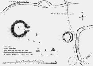
The site consists of a single circular bank built using cobble stones from the nearby rivers. The bank is up to 15 feet (6.5 metres) high, and 50 metres across its base with a diameter of around 383 feet (117 metres). Contained within it is a single monolith 9 feet (2.8 metres) high. According to Thomas Pennant, in the early 18th century there had been four standing stones in the centre (marked on his 1769 plan, shown here), and a further four at the entrance, but his contemporary Robert Hutchinson, writing in 1773, gave a slightly different version:
"The inhabitants in the neighbourhood say, that within the memory of man, two other stones of similar nature, and placed in a kind of angular figure with the stone now remaining, were to be seen there, but as they were hurtful to the ground, were destroyed and removed."
No proper excavation has been done at Mayburgh, so it is difficult to date the henge with any certainty, but the presence of Neolithic and Bronze axes found near the site indicate a date in the Neolithic or Bronze Age. In 1992 a magnetometer survey was carried out by Geophysical Surveys of Bradford and English Heritage [2] to confirm any stone settings within the interior and to assess the presence of a ditch, internal or external.
There is no obvious explanation for why Mayburgh was built, but the fact that it is close to the confluence of the rivers Lowther and Eamont have given rise to the theory that it was once a trade centre on a route for stone axe trade from the Neolithic axe factory at Langdale.
Eden Arts Council erected a granite obelisk nearby, called the "Millennium Stone" to mark the year 2000.
The Henge forms part of a selection of prehistoric and historic remains in the surrounding area, including:
- King Arthur's Round Table Henge, 400 metres from Mayburgh Henge.
- Brocavum Roman Camp, Brougham
- Brougham Castle
- Shap Abbey, near Shap
References
- ^ http://www.pastscape.org.uk/hob.aspx?hob_id=12002&sort=4&search=all&criteria=mayburgh&rational=q&recordsperpage=10
- ^ Proceedings of the Prehistoric Society 58/1992 254-5
External links
Coordinates: 54°38′55″N 2°44′48″W / 54.6487°N 2.7467°W
Dating from Neolithic/ Bronze Age Dating from Roman Britain Ambleside Roman Fort · Hadrian's Wall (including Banks East Turret, Birdoswald Roman Fort, Hare Hill, Harrows Scar Milecastle and Wall, King's Stables (Milecastle 48), Leahill Turret and Piper Sike Turret, Pike Hill Signal Tower, Willowford Wall Turrets and Bridge) · Hardknott Roman Fort · Ravenglass Roman Bath HouseDating from the Middle Ages Dating from the 17th Century onwards This article about a Cumbria building or structure is a stub. You can help Wikipedia by expanding it. This article relating to archaeology in the United Kingdom is a stub. You can help Wikipedia by expanding it.


