- Mönchaltorf
-
Mönchaltorf 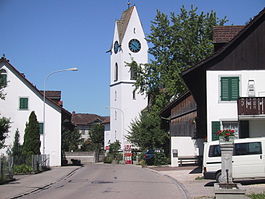
Country Switzerland 
Canton Zurich District Uster 47°19′N 8°43′E / 47.317°N 8.717°ECoordinates: 47°19′N 8°43′E / 47.317°N 8.717°E Population 3,461 (Dec 2010)[1] - Density 454 /km2 (1,176 /sq mi) Area 7.6 km2 (2.9 sq mi)[2] Elevation 442 m (1,450 ft) Postal code 8617 SFOS number 0196 Mayor Annemarie Beglinger Surrounded by Egg, Gossau, Maur, Seegräben, Uster, Wetzikon Website www.moenchaltorf.ch
SFSO statistics
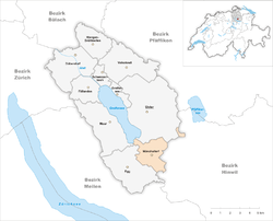
 MönchaltorfMap of Mönchaltorf
Mönchaltorf is a municipality in the district of Uster in the canton of Zürich in Switzerland.
Contents
History
Mönchaltorf is first mentioned in 741 as Villa Altorf. In 872 it was mentioned as Altorf monachorum.[3] It also holds the record for the longest Apfel Strudel.[citation needed]
Geography

Mönchaltorf has an area of 7.6 km2 (2.9 sq mi). Of this area, 70.1% is used for agricultural purposes, while 11.2% is forested. Of the rest of the land, 15.7% is settled (buildings or roads) and the remainder (3%) is non-productive (rivers, glaciers or mountains).[4] In 1996[update] housing and buildings made up 12.1% of the total area, while transportation infrastructure made up the rest (3.7%).[5] Of the total unproductive area, water (streams and lakes) made up 0.3% of the area. As of 2007[update] 12.8% of the total municipal area was undergoing some type of construction.[5]
Demographics
Mönchaltorf has a population (as of 31 December 2010) of 3,461.[1] As of 2007[update], 11.6% of the population was made up of foreign nationals. As of 2008[update] the gender distribution of the population was 48.8% male and 51.2% female. Over the last 10 years the population has grown at a rate of 3.7%. Most of the population (as of 2000[update]) speaks German (92.3%), with Italian being second most common ( 1.7%) and French being third ( 1.0%).
In the 2007 election the most popular party was the SVP which received 39.2% of the vote. The next three most popular parties were the SPS (20.9%), the CSP (11.9%) and the FDP (11.7%).
The age distribution of the population (as of 2000[update]) is children and teenagers (0–19 years old) make up 23.6% of the population, while adults (20–64 years old) make up 66.7% and seniors (over 64 years old) make up 9.8%. In Mönchaltorf about 83.9% of the population (between age 25-64) have completed either non-mandatory upper secondary education or additional higher education (either university or a Fachhochschule). There are 1336 households in Mönchaltorf.[5]
Mönchaltorf has an unemployment rate of 1.87%. As of 2005[update], there were 110 people employed in the primary economic sector and about 36 businesses involved in this sector. 367 people are employed in the secondary sector and there are 37 businesses in this sector. 602 people are employed in the tertiary sector, with 119 businesses in this sector.[4] As of 2007[update] 50% of the working population were employed full-time, and 50% were employed part-time.[5]
As of 2008[update] there were 733 Catholics and 1582 Protestants in Mönchaltorf. In the 2000 census, religion was broken down into several smaller categories. From the census[update], 56.1% were some type of Protestant, with 50.7% belonging to the Swiss Reformed Church and 5.5% belonging to other Protestant churches. 23.9% of the population were Catholic. Of the rest of the population, 0% were Muslim, 3.2% belonged to another religion (not listed), 2.7% did not give a religion, and 13.4% were atheist or agnostic.[5]
Population growth
The following table shows the population development of Möchaltorf.
Population Development Year Inhabitants:[3] 1771 695 1850 1148 1860 1189 1900 804 1941 706 1950 837 1960 1023 1970 1604 1980 2863 1990 3494 2000 3183 Politics
Mayor is Annemarie Beglinger-Vögeli (FDP).
The municipal council:
- Annemarie Beglinger-Vögeli (FDP)
- Stefan Hunger (independent; formerly SVP)
- Rudolf Fürst (SVP)
- Ernst Oertle (independent)
- Karin Bivetti (FDP)
- Peter Riederer (SP)
References
- ^ a b Canton of Zurich Statistical Office (German) accessed 29 March 2011
- ^ Arealstatistik Standard - Gemeindedaten nach 4 Hauptbereichen
- ^ a b Mönchaltorf in German, French and Italian in the online Historical Dictionary of Switzerland.
- ^ a b Swiss Federal Statistical Office accessed 14-Aug-2009
- ^ a b c d e Statistics Zurich (German) accessed 4 August 2009
External links
- Offizielle Website der Gemeinde Mönchaltorf (German)
- Statistische Daten des Kantons zur Gemeinde Mönchaltorf (German)
- Mönchaltorf in German, French and Italian in the online Historical Dictionary of Switzerland.
- Gemeinde Mönchaltorf im GIS des Kantons Zürich (German)
Dübendorf | Egg | Fällanden | Greifensee | Maur | Mönchaltorf | Schwerzenbach | Uster | Volketswil | Wangen-Brüttisellen
Canton of Zürich | Districts of Canton Zürich | Municipalities of the canton of Zurich


Wikimedia Foundation. 2010.