Oshiwara River

Oshiwara River
Oshiwara River
River
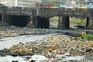
Oshiwara river in Jan 2006
Country India
State Maharashtra
City Mumbai
Source Aarey Milk Colony
 - location Mumbai suburban district, India
Mouth
 - location Arabian Sea, India
 - elevation 3 m (10 ft)
 - coordinates 19°09′33″N 72°48′59″E / 19.15917°N 72.81639°E / 19.15917; 72.81639

Oshiwara River is a river in Mumbai, India. It begins in the Aarey Milk Colony,[1] cuts through the Goregaon hills, across the Aarey Milk Colony before emptying into the Malad Creek. On the way it is joined by another creek near Swami Vivekanand Road, before picking up industrial effluents and sewage while crossing the Oshiwara industrial estates and slums of Andheri. The river is highly polluted and encroachments have shrunk it to a narrow stream. Most of the call centres in Malad have been built on reclaimed ground at the mouth of the river.

After the 2005 Maharashtra floods in Mumbai, efforts are on to widen and cleanup the river. Some proposals include converting it into a waterway for barges, setting up small farms on its banks and introduce biogas plants to convert waste into energy.[2]

References

  • A Tale of Two Rivers; Times of India (Mumbai); Vaishnavi C Sekhar/TNN, 2006-01-09. (pdf version)

Wikimedia Foundation. 2010.

Игры ⚽ Поможем написать реферат

Look at other dictionaries:

  • Oshiwara — (Marathi: ओशिवाडा) is a neighbourhood in northern Mumbai, India very near to Lokhandwala Complex. The name of this neighbourhood was derived from the Oshiwara River. Located between the western sides of Goregaon and Jogeshwari, it has a large… …   Wikipedia

  • Mithi River — at Bandra The Mithi river is in the centre. The …   Wikipedia

  • Dahisar River — River Country India State Maharashtra …   Wikipedia

  • Salsette Island — Infobox Islands name = Salsette image caption = The metropolis of Mumbai (formerly Bombay) and the city of Thane lie on Salsette Island. image size = locator Location map|India|lat=20|long=72 map custom = yes native name = साष्टी native name link …   Wikipedia

  • Mumbai Suburban District — मुंबई उपनगर जिल्हा Location of Mumbai Suburban district in Maharashtra State …   Wikipedia

  • Salsette — Vorlage:Infobox Insel/Wartung/Höhe fehlt Salsette Satelliten Aufnahme von Salsette Gewässer …   Deutsch Wikipedia

  • Sashti — Satelliten Aufnahme von Salsette Salsette (Portugiesisch: Salsete, Marathi: साष्टी, sāṣṭī, Sashti) ist eine 619 Quadratkilometer große Insel vor der Westküste des indischen Bundesstaates Maharashtra. Auf ihr befinden sich die beiden… …   Deutsch Wikipedia

  • Chandivali (Vidhan Sabha constituency) — Chandivali Vidhan Sabha constituency (Marathi: चांदिवली विधान सभा मतदारसंघ) is one of the 288 Vidhan Sabha constituencies of Maharashtra state in western India.[1] Contents 1 Overview 2 Members of Legislative Assembly …   Wikipedia

  • Charkop (Vidhan Sabha constituency) — Charkop Vidhan Sabha constituency (Marathi: चारकोप विधान सभा मतदारसंघ) is one of the 288 Vidhan Sabha (Legislative Assembly) constituencies in Maharashtra state in western India. Contents 1 Overview 2 Members of Legislative Assembly 3 …   Wikipedia

  • Chembur (Vidhan Sabha constituency) — Chembur Vidhan Sabha constituency (Marathi: चेंबुर विधान सभा मतदारसंघ) is one of the 288 Vidhan Sabha (legislative assembly) constituencies of Maharashtra state in western India.[1] Contents 1 Overview 2 Members of Legislative Assembly …   Wikipedia

Share the article and excerpts

Direct link
Do a right-click on the link above
and select “Copy Link”