Chillington — may refer to: Chillington, Devon Chillington, Somerset Chillington Hall, Staffordshire Chilton, Wisconsin, originally named Chillington after one of the English towns This disambiguation page lists articles about distinct geographical locations… … Wikipedia
Chillington, Somerset — Coordinates: 50°53′45″N 2°52′10″W / 50.8958°N 2.8695°W / 50.8958; 2.8695 … Wikipedia
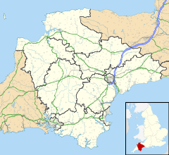
List of places in Devon — This is a list of settlements and places of interest in Devon, England. See List of places in England for settlements in other counties. NOTOC A*Abbots Bickington *Abbotsham *Abbotskerswell *Alverdiscott *Appledore (Mid Devon) *Appledore (North… … Wikipedia
Monarch's Way — Waymark on a Public Footpath Length 615 miles (990 km) Location Warwickshire, Worcestershire, Staffordshire, Sussex, Gloucesters … Wikipedia
South Hams — is a local government district on the south coast of Devon, England. It contains the towns of Dartmouth, Kingsbridge, Ivybridge, Salcombe, and Totnes, where the district council has its offices.To the north it includes part of Dartmoor National… … Wikipedia
Chard, Somerset — Coordinates: 50°52′22″N 2°57′31″W / 50.8728°N 2.9587°W / 50.8728; 2.9587 … Wikipedia
New World Tapestry — The New World Tapestry is the largest stitched embroidery in the world,[1] larger than the Bayeux Tapestry. It depicts English colonisation attempts in Newfoundland, North America, the Guyanas and Bermuda between the years 1583 and 1642, when the … Wikipedia
Stokenham — is a village and civil parish in the English county of Devon. Stokenham civil parish includes the settlements of Torcross, Beesands, Hallsands, Kellaton, Kernborough, Dunstone, Beeson and Chillington as well as Stokenham itself[1]. It forms part… … Wikipedia
Lancelot “Capability” Brown — Lancelot Brown (1716 ndash;6 February, 1783), more commonly known as Capability Brown, was an English Landscape architect. He is remembered as the last of the great English eighteenth century artists to be accorded his due , and England s… … Wikipedia
Crewkerne — Coordinates: 50°52′49″N 2°47′38″W / 50.8803°N 2.7939°W / 50.8803; 2.7939 … Wikipedia
 Chillington