Kgalagadi District

Kgalagadi District

Demographic info|name=Kgalagadi
capital=Tshabong
population=42,049
census=2001
area=106,940
density=0.39

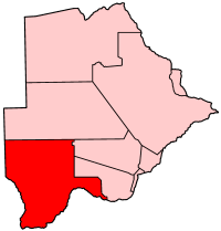
Kgalagadi is a district in southwest Botswana, lying along the country's border with Namibia and South Africa. The administrative center is Tshabong. Kgalagadi covers a vast area of the Kalahari Desert. It has a total area of 105,200 km², and has a population of only 42,000 (2001). More than one-third of the district is covered by the Kgalagadi Transfrontier Park, which extends into South Africa.

Location

Kgalagadi's location causes it to border the following regions and provinces:
*Omaheke Region, Namibia - northwest
*Hardap Region, Namibia - southwest
*Northern Cape Province, South Africa - south
*North West Province, South Africa - southeastDomestically, it borders the following districts of Botswana:
*Ghanzi District - north
*Kweneng District - northeast
*Southern District - east

ub-districts

Sub-districts of Kgalagadi District include:
* Kgalagadi North
* Kgalagadi South

ettlements

The largest settlement in the district is Tshabong, which had a population of 6,591 in 2001 census while Hukuntsi and Kang had 3,807 and 3,744, respectively. The following is the list of villages noted separately in 2001 census in each census region. [cite web
url=http://www.cso.gov.bw/html/census/dist90_91.html
title=Distribution of population by sex by villages and their associated localities: 2001 population and housing census
accessdate = 2007-12-10
]

Kgalagadi South:: Bogogobo, Bokspits, Bray, Gachibana, Khisa, Khuis, Khwawa, Kokotsha, Kolonkwane, Makopong, Maleshe, Maralaleng, Maubelo, Middlepits, Omaweneno, Phepheng (Draaihoek), Rapples Pan, Struizendam, Tshabong, Vaalhoek, Werda

Kgalagadi North:: Hukuntsi, Hunhukwe, Inalegolo, Kang, Lehututu, Lokgwabe, Make, Monong, Ncaang, Ngwatle, Phuduhudu, Tshane, Ukwi, Zutswa

ee also

*Sub-districts of Botswana

References


Wikimedia Foundation. 2010.

Игры ⚽ Поможем сделать НИР

Look at other dictionaries:

  • Kgalagadi District Municipality — Kgalagadi Kgalagadi District Municipality Kgalagadi (blau) in Nordkap (dunkelgrau) Staat: Südafrika …   Deutsch Wikipedia

  • Kgalagadi District — Kgalagadi Basisdaten Staat Botsuana …   Deutsch Wikipedia

  • Kgalagadi District Municipality — Zamuni code=DC45 location= area= seat=Kuruman neighbours= mayor= population=176 899 [ [http://www.demarcation.org.za/municprofiles2003/index.asp Municipal Profiles] ] population density= habitations= habitation density= races= languages=Setswana… …   Wikipedia

  • Kgalagadi (Distrikt) — Kgalagadi Kgalagadi District Municipality Kgalagadi (blau) in Nordkap (dunkelgrau) Staat: Südafrika …   Deutsch Wikipedia

  • Kgalagadi — bezeichnet: die Kalahari Wüste auf Setswana eine Sprache im südlichen Afrika, siehe Kgalagadi (Sprache) einen Distrikt in Botsuana, siehe Kgalagadi District einen Distrikt in der südafrikanischen Nordkap Provinz, siehe Kgalagadi District… …   Deutsch Wikipedia

  • Kgalagadi — means land of the thirst. It is located in Southern Africa.It may refer to the region in general or to one of the districts of Botswana, named Kgalagadi District.There is also the Kgalagadi Transfrontier Park …   Wikipedia

  • District De Kgalagadi — Kgalagadi Administration Pays Botswana Type District Capitale Tshabong Géographie …   Wikipédia en Français

  • District de kgalagadi — Kgalagadi Administration Pays Botswana Type District Capitale Tshabong Géographie …   Wikipédia en Français

  • District De Kgatleng — Kgatleng Administration Pays Botswana Type District Capitale Mochudi Géographie …   Wikipédia en Français

  • District de kgatleng — Kgatleng Administration Pays Botswana Type District Capitale Mochudi Géographie …   Wikipédia en Français

Share the article and excerpts

Direct link
Do a right-click on the link above
and select “Copy Link”