- Elim Airport
Infobox Airport
name = Elim Airport
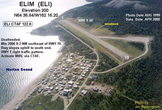
image-width = 250
IATA = ELI
ICAO = PFEL
FAA = ELI
type = Public
owner = State of Alaska DOT&PF - Northern Region
operator =
city-served =Elim, Alaska
location =
elevation-f = 162
elevation-m = 49
coordinates = coord|64|36|54|N|162|16|14|W|region:US_type:airport_scale:10000
website =
r1-number = 1/19
r1-length-f = 3,401
r1-length-m = 1,037
r1-surface = Gravel
stat1-header = Enplanements (2007)
stat1-data = 3,189
footnotes = Source:Federal Aviation Administration FAA-airport|ID=ELI|use=PU|own=PU|site=50197.*A, retrieved 2008-07-31.] [http://www.faa.gov/airports_airtraffic/airports/planning_capacity/passenger_allcargo_stats/passenger/ Preliminary CY 2007 Passenger Boarding and All-Cargo Data] . Federal Aviation Administration. 2008-07-17.]Elim Airport airport codes|ELI [ [http://aviation-safety.net/database/airport/airport.php?id=ELI ELI: Elim Airport, Alaska] . Aviation Safety Network. Retrieved 2008-09-21.] |PFEL [ [http://www.airnav.com/airport/PFEL PFEL: Elim Airport, Alaska] . AirNav.com. Retrieved 2008-09-21.] |ELI is a state-owned public-use
airport located threenautical mile s (6 km) southwest of thecentral business district of Elim, a city in the Nome Census Area of theU.S. state ofAlaska .As per
Federal Aviation Administration records, this airport had 3,189 passenger boardings (enplanements) incalendar year 2007, an decrease of 15% from the 3,772 enplanements in 2006.Facilities
Elim Airport covers an area of 99
acre s (40 ha) at anelevation of 162 feet (49 m) abovemean sea level . It has onerunway designated 1/19 with a 3,401 by 60 ft (1,037 x 18 m)gravel surface.Airlines and non-stop destinations
*
Bering Air (Golovin, Koyuk) [ [http://beringair.com/pdf/ome.pdf Nome Flight Schedule] (PDF ). Bering Air. Retrieved 2007-08-29.]
*Frontier Flying Service (Golovin, Koyuk) [ [http://www.frontierflying.com/timetable-ffs.pdf 2007 Timetable] (PDF ). Frontier Flying Service. Retrieved 2007-08-29.]
*Hageland Aviation Services (Golovin, Nome) [ [http://www.hageland.com/07sched.pdf Scheduled Flights] (PDF ). Hageland Aviation Services. Retrieved 2007-08-29.]References
External links
* [http://www.alaska.faa.gov/fai/images/ARPT_DIAGRAMS/ELI.gifAlaska FAA airport diagram] (
GIF )
*
* Resources for this airport:
** AirNav|ELI
** ASN|ELI
** SkyVector|ELI
Wikimedia Foundation. 2010.