- Osterhofen
-
Osterhofen 

 OsterhofenLocation of the town of Osterhofen within Deggendorf district
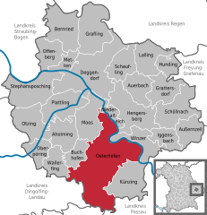
Coordinates 48°42′N 13°01′E / 48.7°N 13.01667°ECoordinates: 48°42′N 13°01′E / 48.7°N 13.01667°E Administration Country Germany State Bavaria Admin. region Lower Bavaria District Deggendorf Mayor Liane Sedlmeier (FW) Basic statistics Area 111.19 km2 (42.93 sq mi) Elevation 318 m (1043 ft) Population 11,669 (31 December 2010)[1] - Density 105 /km2 (272 /sq mi) Other information Time zone CET/CEST (UTC+1/+2) Licence plate DEG Postal code 94486 Area code 09932 Website www.osterhofen.de Osterhofen is a town in the district of Deggendorf, in Bavaria, Germany. It is situated on the right bank of the Danube, 16 km south of Deggendorf.
Aholming | Auerbach | Außernzell | Bernried | Buchhofen | Deggendorf | Grafling | Grattersdorf | Hengersberg | Hunding | Iggensbach | Künzing | Lalling | Metten | Moos | Niederalteich | Oberpöring | Offenberg | Osterhofen | Otzing | Plattling | Schaufling | Schöllnach | Stephansposching | Wallerfing | Winzer
References
- ^ "Fortschreibung des Bevölkerungsstandes" (in German). Bayerisches Landesamt für Statistik und Datenverarbeitung. 31 December 2010. https://www.statistikdaten.bayern.de/genesis/online?language=de&sequenz=tabelleErgebnis&selectionname=12411-009r&sachmerkmal=QUASTI&sachschluessel=SQUART04&startjahr=2010&endjahr=2010.
Categories:- Geography articles needing translation from German Wikipedia
- Towns in Bavaria
- Deggendorf district
- Lower Bavaria geography stubs


![[1]](http://web.archive.org/web/20030323132517/http://www.osterhofen.de/basilika.jpg)
![[2]](http://web.archive.org/web/20030323125346/http://www.osterhofen.de/OH9ay.jpg)
Wikimedia Foundation. 2010.