- Saxon Axis
-
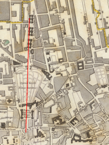
The Saxon Axis (Polish: Oś Saska) is a feature of the historical city centre of the city of Warsaw. It is a line running from the Vistula through the Presidential Palace, the Krakowskie Przedmieście, Saxon Square, Saxon Palace, Saxon Garden, Lubomirski Palace to Plac Żelaznej Bramy.[1][2]
The idea was first proposed by August II of Poland, who intended to build a large Royal palace surrounded by a French-style garden. The plan was loosely based on the baroque design of the Versailles and was to cover a large part of what is now the city of Warsaw. The main concept, which gave the name to the modern part of the city, assumed the construction of the Saxon Palace, with gardens extending to the both sides along a single axis running exactly through its middle.
Between 1713 and 1726 the king bought 28 various parcels located in the area and invited Matthäus Daniel Pöppelmann and Johann Christoph Naumann to design the urban plan. However, financial difficulties made the plan never come true in its entirety. Although the Saxon Garden and the Saxon Palace were constructed, the planned demolition of the Lubomirski Palace at the Plac Żelaznej Bramy had to be called off after August's death in 1733.
During the World War II and the Warsaw Uprising of 1944, all of the buildings located along the axis were demolished by the Germans. After the war, the Saxon Palace was not rebuilt. However, the garden was refurbished and the demolished Lubomirski Palace was rebuilt, but was rotated to fit into the 18th century scheme. In recent times also the Warsaw University Library located at the Vistula below the river escarpment was added to the list of buildings with main entrances located along the axis, and there was a large golden tablet placed in the pavement in front of it marking the line running through the city centre.
References
- ^ "ScienceDirect - Automation in Construction : Virtual representation of the historic space riches". www.sciencedirect.com. http://www.sciencedirect.com/science?_ob=ArticleURL&_udi=B6V20-491J4R6-2&_user=10&_rdoc=1&_fmt=&_orig=search&_sort=d&view=c&_acct=C000050221&_version=1&_urlVersion=0&_userid=10&md5=901e2c0d11d0737e1f5db1533467dd8b. Retrieved 2008-03-21.
- ^ Katarzyna Murawska-Muthesius. "Art under the Polish-Saxon Union. Warsaw and Dresden". JSTOR: The Burlington Magazine: Vol. 139, No. 1136 (Nov., 1997), pp. 813-815. http://links.jstor.org/sici?sici=0007-6287(199711)139%3A1136%3C813%3AAUTPUW%3E2.0.CO%3B2-F. Retrieved 2008-03-21.
Categories:- Urban planning in Poland
- Geography of Warsaw
- History of Warsaw
- Warsaw geography stubs
Wikimedia Foundation. 2010.

