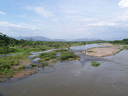
Choluteca River

Choluteca River
Choluteca River
River
Choluteca River near the city of Choluteca
Country Honduras
Source
 - location Choluteca, Choluteca, Honduras
Mouth Pacific Ocean
 - elevation 0 m (0 ft)
Length 349 km (217 mi)
Basin 7,681 km2 (2,966 sq mi)

The Choluteca River (Spanish: Río Grande o Choluteca) is a river in southern Honduras. Its source is in the department of Francisco Morazán, near Lepaterique (south-west Tegucigalpa), and from there it flows North through the city of Tegucigalpa, then South through the department of El Paraíso, and the department and city of Choluteca. The mouth of the river -located among wetland- is near the coastal town of Cedeño, on the Gulf of Fonseca.

According to FAO, the Choluteca River has 349 km of extension from his source to his mouth. Its hydrographic basin has an area of 7,681 km². [1] It increases his volume between May and October, together with the rainy season. Its basin is affected by severe drought together with El Niño phenomenon, and this is usually associated with severe bush fires.

There are no dams built along the main course of the river to leave it to its natural health[citation needed].

The flooding of this river was a major source of destruction in Hurricane Mitch in 1998. It washed out entire neighborhoods in Tegucigalpa, and eventually swelled to six times its normal size in Choluteca. There it destroyed neighborhoods and part of the commercial center. Further down it also devastated the tiny Morolica, where it not only destructed the entire hamlet but nearly all its inhabitants died or disappeared.

See also

  • Rivers of Honduras
  • Water Resources Management: The Choluteca river basin in Honduras
  • Water Resources Management in Honduras

References


Wikimedia Foundation. 2010.

Игры ⚽ Нужно решить контрольную?

Look at other dictionaries:

  • Choluteca river basin — The Choluteca river basin lies on the hot and dry southern Pacific coast of Honduras, and is bordered by Nicaragua to the east. The name Choluteca, thought to mean ‘broad valley,’ originates from the indigenous Chorotega tribe who inhabited the… …   Wikipedia

  • Choluteca, Choluteca — Choluteca …   Wikipedia

  • Choluteca — may refer to: Choluteca, Choluteca a city in Honduras Choluteca (department), a governmental region in Honduras Choluteca River, a river in southern Honduras This disambiguation page lists articles associated with the same title. If an …   Wikipedia

  • Choluteca — /chaw looh te kah/, n. a city in S Honduras. 43,551. * * * ▪ Honduras       city, southern Honduras. It lies in the hot Pacific lowlands along the Choluteca River. It was founded in 1522 as a mining centre and was given city status in 1845.… …   Universalium

  • Choluteca Department — Choluteca is one of the 18 departments (departamentos) into which the Central American nation of Honduras is divided. It is the southernmost department of Honduras, bordering the Gulf of Fonseca to the west and the Republic of Nicaragua to the… …   Wikipedia

  • Coco River — Coordinates: 15°00′N 83°10′W / 15°N 83.167°W / 15; 83.167 …   Wikipedia

  • Tegucigalpa — Municipio del Distrito Central Municipality of the Central District   City   Tegucigalpa, M.D.C …   Wikipedia

  • List of rivers of Honduras — Rivers in Honduras is a list of the rivers in Honduras, including those which it shares with its neighbours. The most important river in Honduras is the Ulúa, which flows 400 kilometers to the Caribbean through the economically important Valle de …   Wikipedia

  • Hurricane Mitch — Infobox Hurricane Name=Hurricane Mitch Type=hurricane Year=1998 Basin=Atl Image location=Hurricane Mitch 1998 oct 26 2028Z.jpg Formed=October 22, 1998 Dissipated=November 5, 1998 1 min winds=155 Pressure=905 Da Inflated=0 Fatalities=11,000–18,000 …   Wikipedia

  • Duyure — Photograph of Duyure from above …   Wikipedia

Share the article and excerpts

Direct link
Do a right-click on the link above
and select “Copy Link”