- Walvis Bay
Infobox Settlement
name =Walvis Bay
official_name =
other_name =
native_name =
nickname =
settlement_type =
total_type =
motto =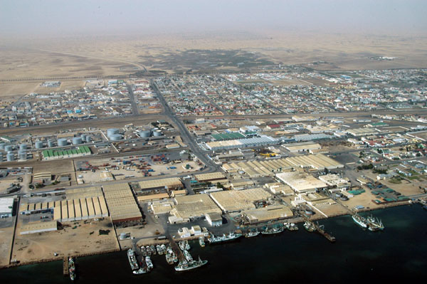
imagesize =
image_caption = Aerial photo of the harbour area
flag_size =
image_
seal_size =
image_shield =
shield_size =
image_blank_emblem =
blank_emblem_type =
blank_emblem_size =
mapsize =
map_caption =
mapsize1 =
map_caption1 =
image_dot_
dot_mapsize =
dot_map_caption =
dot_x = |dot_y =
pushpin_
pushpin_label_position =
pushpin_map_caption =Location within Namibia
pushpin_mapsize =
subdivision_type = Country
subdivision_name = flag|Namibia
subdivision_type1 = Region
subdivision_name1 =Erongo Region
subdivision_type2 =
subdivision_name2 =
seat_type =
seat =
parts_type =
parts_style =
parts =
p1 =
p2 =
government_footnotes =
government_type =
leader_title =Mayor
leader_name =Ulika Nambahu
leader_title1 =
leader_name1 =
established_title = Established
established_date = 1840
area_magnitude =
unit_pref =Imperial
area_footnotes =
area_total_km2 =1124
area_land_km2 =
area_water_km2 =
area_total_sq_mi =
area_land_sq_mi =
area_water_sq_mi =
area_water_percent =
elevation_footnotes =
elevation_m =
elevation_ft =
elevation_max_m =
elevation_max_ft =
elevation_min_m =
elevation_min_ft =
population_as_of =
population_footnotes =
population_note =
population_total =65000
population_density_km2 =30.4
population_density_sq_mi =65.2
timezone = SAST
utc_offset = +2
timezone_DST =
utc_offset_DST =
coor_type =
latd=22 |latm=57 |lats=22 |latNS=S
longd=14 |longm=30 |longs=29 |longEW=E
postal_code_type =
postal_code =
area_code =
website =
footnotes =

Walvis Bay (Dutch/
The bay has been a haven for sea vessels because of its natural deepwater harbour, protected by the Pelican Point
The town is situated in the Kuiseb river delta and lies at the end of the TransNamib Railway to
Walvis Bay, with its large bay and sand dunes, is the tourism activity centre of Namibia. Other attractions include the artificial Bird Island, centre of a
History
[
Little commercial development occurred in the city until 1840, when in the
The enclave was overrun by the Germans during the
In 1971, anticipating an imminent ceding of its control over South-West Africa, South Africa transferred control of Walvis Bay back to its Cape Province. In 1977, in an attempt to avoid losing control of Walvis Bay to a possibly hostile SWAPO-led government, the South African government reimposed direct rule and reasserted its claim of sovereignty based on the original annexation. In 1978, the
In 1990, South-West Africa gained independence as Namibia, but Walvis Bay remained under South African sovereignty. It was not until midnight on
ee also
Literature
* Silverman, Melinda: [http://www.namibiana.de/index.cfm?action=ViewDetails&ItemID=1852"Between the Atlantic and the Namib. An Environmental History of Walvis Bay"] , NWG, Windhoek 2004 - Namibiana Buchdepot
* de Beer, Charles: [http://www.namibiana.de/index.cfm?action=ViewDetails&ItemID=519"Namibia Marine Life"] , @tidude Graphix, Swakopmund o.J. - Namibiana Buchdepot
* Heemstra, Phillip; Smith, Margaret M.: [http://www.namibiana.de/index.cfm?action=ViewDetails&ItemID=2015"Smith's Sea Fishes"] , Struik Publishers, Cape Town 2003
* Bridgeford, P. and M.: [http://www.namibiana.de/index.cfm?action=ViewDetails&ItemID=624"Cape Cross"] , Walvis Bay 2002 - Namibiana Buchdepot
* Vogt, Andreas: [http://www.namibiana.de/index.cfm?action=ViewDetails&ItemID=2220"National Monuments in Namibia"] , Gamsberg Macmillan, Windhoek 2004 - Namibiana Buchdepot
External links
* [http://www.pgoimages.com/gallery.php?gall=g_namibia_swakopmund Images from Walvis Bay]
* [http://www.kuisebonline.com Activities from Walvis Bay]
* [http://www.ports.co.za/walvis-bay.php Walvisbay Port Information]
* [http://www.walvisbaycc.org.na/ Walvis Bay City Council]
* [http://africa.cwsurf.de/WalvisBay.htm Walvis Bay Airport Information]
* [http://www.info.gov.za/acts/1993/a203-93.pdf Transfer of Walvis Bay To Namibia Act, 1993]
Wikimedia Foundation. 2010.