- Nelly Bay, Queensland
-
Nelly Bay
Magnetic Island, Queensland
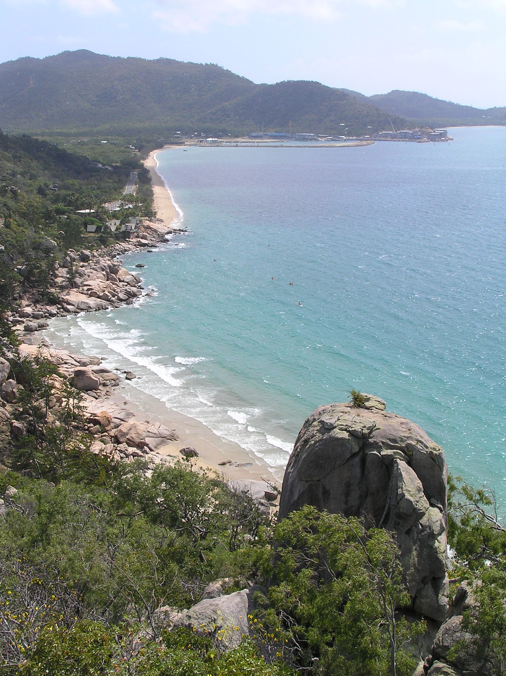
Rocky Bay (foreground) and Nelly Bay foreshore, showing Magnetic Harbour in the distance.Population: 973 (2006 Census)[1] Postcode: 4819 LGA: City of Townsville County: Elphinstone Parish: Magnetic State District: Townsville Federal Division: Herbert Suburbs around Nelly Bay: Arcadia Picnic Bay Nelly Bay Nelly Bay is a village on Magnetic Island, and a suburb of the City of Townsville, Australia. A tourism hub on the island, it is especially significant as the site of the ferry terminal, which links it to Townsville. At the 2006 census, Nelly Bay had a population of 973.[1]
Contents
Magnetic Harbour
 Nelly Bay Ferry Terminal (on right) with construction at Magnetic Harbour (to see, click on the blank and then click on the image after the file opened)
Nelly Bay is also home to Magnetic Island's largest infrastructure development, Magnetic Harbour, also known as Nelly Bay Harbour. The development consists of a new ferry and barge terminal, an emergency services helipad, retail services, and mixed residential dwellings throughout the project.
Currently, Magnetic Harbour is the arrival and departure point for ferries and barges traveling to and from Townsville, with numerous services each day between both passenger ferry operator Sunferries and vehicle and passenger barge operator Fantasea Cruising Magnetic.
The harbour is also undergoing major development with numerous apartment and accommodation complexes currently under construction there.
History
Very little information can be found on the history of Nelly Bay. It is however known that Robert Hayles, a local entrepreneur, did start tourist ventures in the bay around 1911 and in 1917 correspondence between the Townsville Harbour Board and the Queensland Marine department notes the existence of a jetty in the bay.[2] During the Second World War an anti-aircraft battery was built on the foreshore of the bay, while the concrete foundations of the battery still exist they area around them has been heavily developed and the foundations have become overgrown.[3]
Magnetic Harbour development
In February 1984 Bob Katter Jr., the new northern development minister, announced the $100 million development of a harbour and marina precinct in Nelly Bay proposed by Mr. Geoff Orpin, a former Maroochy Shire Councillor who moved to Magnetic Island in 1980. At the time the project was to be called Magnetic Keys, and Mr Katter insisted all environmental concerns would be addressed and construction would begin within six months. It was another 18 months before the developer was even able to attain the correct permission and leases to perform feasibility and environmental impact studies in the bay.[4] In 1987 the development was sold to Linkon Group and Essington Developments[5] but Essington Developments sold their interests in the project soon-after to Pacific Properties Pty Ltd.[4]
However, despite the extreme interest in the development of the site, the Great Barrier Reef Marine Park Authority (GBRMPA) had still not granted a permit to develop a harbour in the bay due to the possible environmental effects of the proposed development. In October 1987 GBRMPA changed the zoning of the bay to permit a harbour development but waited until October the following year before controversially issuing a permit to allow the construction of the development to proceed. The permit included certain conditions the developer had to meet, one of which included obtaining rehabilitation insurance which would cover an eventuality where the development did not proceed and rehabilitation of the environment was necessary. At around the same time the Townsville City Council, originally opposed to the development, rezoned the Bright Point area for tourist usage and requested state government ministerial rezoning for the entire development. The Townsville City Council further approved the construction of a hotel and unit development on the Bright Point headland which also allowed the headland to be quarried in the pretext of terraforming the site for the development.[4]
Major construction works started in August 1989, under heavy objection from local residents and environmental groups.[citation needed] The following year saw a number of court cases and tribunals held in opposition to the project. Ultimately none of these cases resulted in a halt of construction work on the site. It later was discovered that there was an unrecorded donation from the developer to Townsville Mayor Tony Mooney's election campaign as well as other possible improprieties between Townsville City Council employees and one of the judges overseeing a case appealing the development. It was further discovered that the developer had offered the GBRMPA a bribe during its deliberation over the proposed development a few years earlier.[4]
In 1990 one of the main lenders for the project collapsed followed by one of the major stakeholders in the project, Pacific Properties. However, work continued to accelerate until July 1990 when the dredge being used on the project sank, followed shortly by the collapse of the Magnetic Keys Consortium. It was then revealed that the required rehabilitation insurance had not been obtained by the developer as was the condition under the original GBRMPA permit. The development land fell back into the hands of the state government who was at the time unable to do anything with the land.[4]
In 1995 a number of proposals were put forward to complete the project which had remained half-completed for the previous five years.[6] None of the proposals went ahead and again in 1998 proposals were again being taken to complete the harbour development. The revised plans for the 1998 development, which were based on the 1995 plans but resolved a number of issues with the 1995 development, reduced the number of lots on the site from 88 to 40 and more than halved the proposed capacity of the development from 1328 residents and tourists to 638.[7] The development proposed in 1998 is the final plan which went ahead with some minor alternations.
In 2003 the new ferry terminal in the Magnetic Harbour development began operational use by passenger ferry operator, Sunferries, shortly followed by vehicle ferry operator, Fantasea. While the development was severely scaled back from its original scope, parts of the development have stalled including the development of a small retail and entertainment precinct next to the ferry terminal. The sale of units in the Peppers Blue on Blue development in Nelly Bay have also been nowhere near as good as expected and there have been a number of issues with breaches in the harbour's retaining walls. Furthermore, while many of the homesites that are part of the harbour have been sold, work is yet to begin on many of the homesites due to engineering difficulties.
References
- ^ a b Australian Bureau of Statistics (25 October 2007). "Nelly Bay (Urban Centre/Locality)". 2006 Census QuickStats. http://www.censusdata.abs.gov.au/ABSNavigation/prenav/LocationSearch?collection=Census&period=2006&areacode=UCL343600&producttype=QuickStats&breadcrumb=PL&action=401. Retrieved 13 June 2011.
- ^ "Picnic Bay Jetty (entry CHIMS17043 )". Queensland Heritage Register. Queensland Environmental Protection Agency. http://www.epa.qld.gov.au/chims/placeDetail.html?siteId=17043. Retrieved 5 September 2009.
- ^ "Nelly Bay Gunsite - 16 Heavy Anti-aircraft Battery". Peter Dunn's Australia at War. 3 April 2002. http://home.brisnet.org.au/~dunn/ozatwar/nellybayaa.htm. Retrieved 6 September 2009.
- ^ a b c d e "Nelly Bay, Magnetic Island Development". Rivermouth Action Group Inc. http://www.rag.org.au/phildickiestories/Walkden.htm. Retrieved 6 September 2009.
- ^ "Magnetic Keys Proposal". Nelly-Bay.com. http://www.nelly-bay.com/magnetic-keys-proposal.html. Retrieved 6 September 2009.
- ^ "Nelly Bay Harbour Proposal 1995". Nelly-Bay.com. http://www.nelly-bay.com/nelly-bay-harbour-proposal-1995.html. Retrieved 6 September 2009.
- ^ "Nelly Bay Safe Harbour - Magnetic Harbour 1998". Nelly-Bay.com. http://www.nelly-bay.com/magnetic-harbour-1998.html. Retrieved 6 September 2009.
Suburbs of Townsville | North Queensland | Queensland Urban Aitkenvale · Annandale · Belgian Gardens · Bohle · Castle Hill · Cluden · Condon · Cranbrook · Currajong · Douglas · Garbutt · Gulliver · Gumlow · Heatley · Hermit Park · Hyde Park · Idalia · James Cook University · Kelso · Kirwan · Lavarack Army Barracks · Mount Louisa · Mount St John · Mount Stuart · Mundingburra · Murray · Mysterton · North Ward · Oonoonba · Pallarenda · Pimlico · Railway Estate · Rasmussen · Rosslea · Rowes Bay · Shaw · South Townsville · Thuringowa Central · Townsville City · Vincent · West End · Wulguru
Rural Alice River · Alligator Creek · Balgal Beach · Black River · Blue Hills · Bluewater Park · Bohle Plains · Brookhill · Calcium · Cape Cleveland · Cleament · Crimea · Crystal Creek · Cungulla · Hervey Range · Hidden Valley · Julago · Lynam · Majors Creek · Mount Elliot · Mutarnee · Nome · Oak Valley · Orpheus Island · Palm Island · Partington · Pinnacles · Rangewood · Reid River · Rollingstone · Roseneath · Rupertswood · Stuart · Toomulla · Toonpan · Woodstock
Northern Beaches Beach Holm · Bluewater · Burdell · Bushland Beach · Deeragun · Jensen · Mount Low · Purono Park · Saunders Beach · Toolakea · Yabulu
Magnetic Island Arcadia · Cockle Bay · Horseshoe Bay · Magnetic Island · Nelly Bay · Picnic Bay
Coordinates: 19°19′14.22″S 146°50′55.55″E / 19.3206167°S 146.8487639°E
Categories:- North Queensland
- Townsville
- Towns in Queensland
- Bays of Queensland

Wikimedia Foundation. 2010.