- Etienne Brule Park
-
Etienne Brulé Park 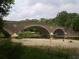
Etienne Brulé ParkType Public Park Location Toronto, Ontario Etienne Brulé Park is located in the Humber River valley just north of Bloor Street West in Toronto, Ontario. It is named after Étienne Brûlé, an early French explorer in the Toronto area.
Contents
Characteristic features
The Old Mill and The Old Mill Bridge - Mills have existed at this site since 1793 when King’s Mill, Toronto’s first industrial building, supplied wood for the construction of Fort York (1793) and early Toronto. A bridge has stood over the Humber River at this location since 1837. The present arched stone bridge was built in 1916. Both the mill and the bridge are historically significant and have been designated under the Ontario Heritage Act.
Fishing at the park
Significant improvements are being made to the health of this fishery based on the Humber River Fisheries Management Plan.
- One of the projects is to improve fish movement in the watershed. Many of the dams from the Old Mill to Palgrave in the Town of Caledon have already been modified to enhance fish migration and the access to 70 km of fish habitat that has been disconnected from Lake Ontario for over 150 years.
- Other initiatives to help protect fish during the sensitive life cycle periods and to promote angling opportunities are also underway.
Entrances and public transit
 Park entrance
Etienne Brulé Park can be entered at the south from Old Mill Road or at the north from Lundy Avenue. The park is only five minutes walk from Old Mill subway station. Pedestrians and cyclists can also travel through the park on the Tommy Thompson Trail, using entrances at Pasadena Gardens and Lundy Avenue.
External links
Coordinates: 43°39′13″N 79°29′41″W / 43.653700°N 79.494720°W
Categories:- Parks in Toronto


Wikimedia Foundation. 2010.