Milford Mills, Pennsylvania

Milford Mills, Pennsylvania
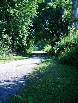
An portion of Milford Road abandoned following the construction of the Marsh Creek dam.

Milford Mills was a village in the Marsh Creek Valley of Chester County, Pennsylvania that was inundated by the construction of the Marsh Creek[disambiguation needed ] Dam in 1972.

Milford Mills was one of several farming villages settled by Welsh, Scots-Irish and English in the first quarter of the 18th century in Upper Uwchlan Township. Like nearby Lyndell and Dorlan, Milford Mills grew during the 19th century as paper and textile manufacturing flourished. Bypassed by large-scale industry in the late 19th century, the region reverted to an agricultural economy until after World War II when the Pennsylvania Turnpike brought suburban development to northwestern Chester County.

From 1964-1972 the State of Pennsylvania acquired properties throughout the region for the Marsh Creek Dam project, relocating residents and finally razing the village entirely. Today the site lies beneath the 530-acre (2.1 km2) Marsh Creek Lake: part of a water management project operated by the Chester County Water Resources Authority and the State of Pennsylvania.

Abandoned roads and traces of houses, barns and other structures can be seen on the shores of the lake and in adjacent recreation areas in Marsh Creek State Park.

References

Quillman, Catherine C. The story of Milford Mills and the Marsh Creek Valley, Devon, PA: privately printed, 1989

Coordinates: 40°03′54″N 75°43′42″W / 40.065°N 75.72833°W / 40.065; -75.72833


Wikimedia Foundation. 2010.

Игры ⚽ Поможем написать курсовую

Look at other dictionaries:

  • Milford Mill — refers to the following places in the suburbs of Baltimore, Maryland, in the United States: Milford Mill, Maryland, a census designated place in Baltimore County near Pikesville and Randallstown Milford Mill Road, a major road in Baltimore County …   Wikipedia

  • List of Pennsylvania locations by per capita income — Pennsylvania locations by per capita income is a list of all incorporated areas and census designated places in Pennsylvania ranked from highest capita income to lowest per capita income. There are many communities not on the list because they… …   Wikipedia

  • Pennsylvania Route 35 — PA 35 redirects here. PA 35 may also refer to Pennsylvania s 35th congressional district. PA Route 35 Route information Maintained by PennDOT …   Wikipedia

  • Milford, New Jersey — See also: West Milford, New Jersey and New Milford, New Jersey Milford, New Jersey   Borough   …   Wikipedia

  • Chester Springs, Pennsylvania — Coordinates: 40°05′42″N 75°37′01″W / 40.095°N 75.61694°W / 40.095; 75.61694 …   Wikipedia

  • Upper Uwchlan Township, Pennsylvania — Geobox Township name = Upper Uwchlan Township native name = other name = other name1 = category = Township image size = image caption = flag size = symbol = symbol size = country = United States state = Pennsylvania region = Chester region type …   Wikipedia

  • List of high schools in Pennsylvania — This is a complete list of Senior High Schools in the state of Pennsylvania, United States. Contents 1 Adams County 2 Allegheny County …   Wikipedia

  • National Register of Historic Places listings in Montgomery County, Pennsylvania — Location of Montgomery County in Pennsylvania This is a list of the National Register of Historic Places listings in Montgomery County, Pennsylvania. This is intended to be a complete list of the properties and districts on National Register of… …   Wikipedia

  • Harrisburg, Pennsylvania — Harrisburg redirects here. For other uses, see Harrisburg (disambiguation). Harrisburg   City   City of Harrisburg …   Wikipedia

  • Juniata County, Pennsylvania — Location in the state of Pennsylvania …   Wikipedia

Share the article and excerpts

Direct link
Do a right-click on the link above
and select “Copy Link”