Devoke Water

Devoke Water
Devoke Water
Location Lake District, Cumbria
Coordinates 54°21′N 3°18′W / 54.35°N 3.3°W / 54.35; -3.3Coordinates: 54°21′N 3°18′W / 54.35°N 3.3°W / 54.35; -3.3
Primary outflows Black Beck
Basin countries United Kingdom
Surface elevation 770 ft (223 m)

Devoke Water is a small lake in the mid-west region of the English Lake District, in the county of Cumbria. It is the largest tarn in the Lake District.

It lies on Birker Fell, 1 km to the west of the road between Ulpha and Eskdale, at an altitude of 770 feet (223 m). It has a depth of 46 ft (14 m).

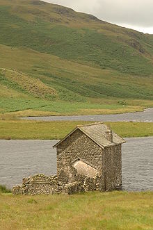
It can be reached via a bridle track. There is a two storey stone boathouse-cum-refuge and a ruined stable.

Dedvoke waters Eskdale Cumbria.JPG

Devoke Water has an outlet in the north west, via Black Beck, which, after a short distance, plunges over rocks down a 26 ft (8 m) cascade, towards the River Esk.

The fishing rights to Devoke Water are owned by Millom Anglers and it is stocked with brown trout. It also holds perch.


Wikimedia Foundation. 2010.

Игры ⚽ Нужен реферат?

Look at other dictionaries:

  • Birker Fell — is an upland wilderness area in the western portion of the Lake District National Park, in Cumbria, England. Rather than being formed of one single high peak, the fell is a broad, undulating area, approximately 6km square, with numerous crags and …   Wikipedia

  • Lake District — The Skiddaw massif, town of Keswick and Derwent Water seen from Walla Crag …   Wikipedia

  • List of lakes in the Lake District — This list contains the lakes, tarns and reservoirs in the Lake District National Park in Cumbria, England.Note that only one body of water, Bassenthwaite Lake, is officially named a lake . The name mere or water is usually given to a larger body… …   Wikipedia

  • List of lakes in England — This is a list of lakes and reservoirs in England. Largest lakes and reservoirs LakeArea (sq mi)1Windermere5.692Kielder Reservoir3.863Ullswater3.444Bassenthwaite Lake2.065Derwent Water2.06 Lakes larger than 5 hectares This list is restricted to… …   Wikipedia

  • Cumbrian placename etymology — The county of Cumbria in the north west of England has a long and complex history of human settlement. Geographically, Cumbria is situated right between the four major countries of the British Isles. Historically, the contrasting landscapes… …   Wikipedia

  • Cumbrian toponymy — refers to the study of place names in Cumbria, a county in North West England, and as a result of the spread of the ancient Cumbric language, further parts of northern England and the Southern Uplands of Scotland. The history of Cumbria is marked …   Wikipedia

  • List of Sites of Special Scientific Interest in Cumbria — This is a list of the Sites of Special Scientific Interest (SSSIs) in Cumbria. For other counties, see List of SSSIs by Area of Search.* Alston Shingle Banks * Annaside * Annaside And Gutterby Banks * Appleby Fells * Argill Woods And Pastures *… …   Wikipedia

  • Cumbric language — Cumbric Spoken in Southern Scotland, Cumberland, Westmorland parts of Northumberland, Lancashire and possibly North Yorkshire Extinct 11th–12th century[1] …   Wikipedia

  • Hard Knott — Infobox Mountain Name = Hard Knott Photo = Hard knott.jpg Caption = Hard Knott, seen rising above the Roman fort Elevation = 549 m (1,801 ft) Location = Cumbria, ENG Range = Lake District, Southern Fells Prominence = 154 m Parent peak = Scafell… …   Wikipedia

  • Woodend, Ulpha, Cumbria — See also: Woodend, Egremont, Cumbria Woodend is the name of several places in Cumbria, England. One of these is situated between the Duddon Valley and the village of Ulpha and the valley of Eskdale, high up on Birker Fell, approximately 950 feet… …   Wikipedia

Share the article and excerpts

Direct link
Do a right-click on the link above
and select “Copy Link”