- Mostar interchange
-
 The Mostar Interchange (eastern half)
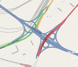 Mostar interchange map (eastern half)
Mostar interchange or colloquially Mostar (Serbian: Mostarska petlja, Мостарска петља) is a major interchange and a surrounding urban neighborhood of Belgrade, the capital of Serbia. It is located in Belgrade's municipality of Savski Venac.
The Mostar looped interchange was constructed in 1974, as one of two major ones (the other one being Autokomanda) on the highway Belgrade–Niš. The highway runs right through the urban center of Belgrade, which is still an issue of debate even though the road was originally intended as a fast, intercity Bežanija-Autokomanda freeway. The interchange itself was built on the location of the old neighborhood of Jatagan Mala. Construction began in 1967 and some technical specifications of the interchange include:
- It covers an area of 20,000 square meters
- It has an elevation of 22 meters
- It's crossed by double tram tracks
- It has 6 underground pedestrian passages and 4 passarellas, leading to 4 bus and 2 tram stops
- A curiosity factor is that it is one of the very few interchanges downtown.
Due to its construction, Mostar incidentally serves as a water collector so during the major rains it gets regularly flooded by the pond created by the rainwater.
A bitter dispute between the mayor of Belgrade, Nenad Bogdanović and a group of architects from the previous city's establishment (including the construction of Mostar and Auto Komanda) resulted in mayor's description of the interchanges from October 2006: 'Those are the two worst interchanges and the only ones in the world with traffic lights...people who made those are today criticizing us.'
The surrounding neighborhood is entirely non-residential. The northern side is occupied by the buildings of the Ministry of the Interior (destroyed in the 1999 NATO bombing of Serbia) and the Clinical Center, which is the largest clinical complex in Belgrade. The southern side comprises the 'BIP' brewery, Prokop train station, a series of half-ruined storages and former factories (which should be replaced by new ones beginning in 2008) and the facilities of the Belgrade Fair. To the west it continues into the Belgrade-Niš highway and to the east to the Novi Beograd and further to Belgrade-Zagreb highway (over the Gazela bridge).
Coordinates: 44°47′55″N 20°26′51″E / 44.79861°N 20.4475°E
Categories:- Serbia geography stubs
- Buildings and structures in Belgrade


Wikimedia Foundation. 2010.