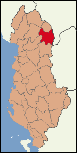
- Kukës District
-
Kukës District — District — Map showing the district within Albania Country  Albania
County Kukës County Capital Kukës Area – Total 938 km2 (362.2 sq mi) Population (2010)[1] – Total 45,616 – Density 48.6/km2 (126/sq mi) The District of Kukës (Albanian: Rrethi i Kukësit) is one of the thirty-six districts of Albania. It has a population 45,616 (2010 estimate) and area of 938 km². The district's only urban municipality is Kukës, which also is where the districts administrative headquarters are located. The district also consists of the following rural municipalities:
- Arrën
- Bicaj
- Bushtricë
- Grykë-Çaje
- Kalis
- Kolsh
- Malzi
- Shishtavec
- Shtiqën
- Surroj
- Tërthorë
- Topojan
- Ujmisht
- Zapod
Geography
The district lies in the northeastern part of Albania and is bordered by District of Prizren in the east and northeast, by Has District in the north, by Pukë District and Mirditë District in the west and by Dibër District in the south.
References
- ^ "POPULLSIA SIPAS PREFEKTURAVE, 2001–2010". Albanian Institute of Statistics. http://www.instat.gov.al/graphics/doc/tabelat/Treguesit%20Sociale/Popullsia/POP%202009/t4%20.xls. Retrieved 2010-09-09.
Districts of Albania Berat · Bulqizë · Delvinë · Devoll · Dibër · Durrës · Elbasan · Fier · Gjirokastër · Gramsh · Has · Kavajë · Kolonjë · Korçë · Krujë · Kuçovë · Kukës · Kurbin · Lezhë · Librazhd · Lushnjë · Malësi e Madhe · Mallakastër · Mat · Mirditë · Peqin · Përmet · Pogradec · Pukë · Sarandë · Shkodër · Skrapar · Tepelenë · Tirana · Tropojë · VlorëCoordinates: 41°58′N 20°25′E / 41.967°N 20.417°E
Categories:- Districts of Albania
- Kukës County
- Kukës County geography stubs
Wikimedia Foundation. 2010.

