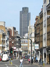
- Borough High Street
-
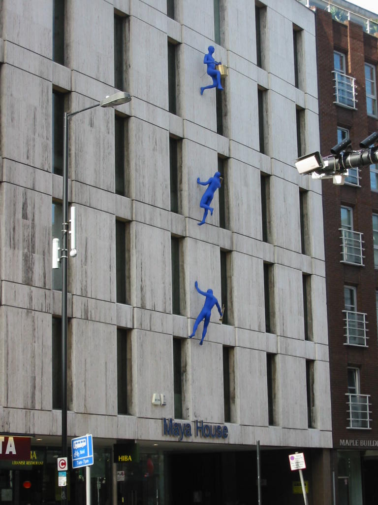
 Blue Men by Ofra Zimbalista climbing Maya House on Borough High Street (March 2007).
Borough High Street is a main street in Southwark, London running south-west from London Bridge, forming part of the A3 road, which runs from London to Portsmouth.
Contents
Overview
Borough High Street continues southwest as Newington Causeway, here co-inciding with ancient Stane Street the Roman road between London and Chichester.[1] Another very important connection is with the Dover Road (the modern A2) which diverges in a south-east direction from Borough High Street at a busy junction of five roads adjacent to Borough tube station as Great Dover Street. The Dover Road mostly follows the alignment of Roman Watling Street, though, here, the original Roman route was along Tabard Street closely parallel with Great Dover Street to the north.[2]
The stretch of Borough High Street south of the junction with Long Lane, Marshalsea Road, and Tabard Street, where stands the ancient church of St George the Martyr, was formerly called 'Blackman Street' after a long resident family there.[3]
The famous Borough Market was once held on the street but has been moved to the west with its main entrance on Southwark Street. Southwark Cathedral, prominent on the west side of the street near London Bridge, can be reached by a small pedestrian bridge and stairs though its postal address is Montague Close.
The earliest recorded name for the street is simply 'The Borough' which was the part between the fork of the street and London Bridge. South of the fork it was called 'St Margaret's Hill'. These names were subsumed in the Tudor period as 'Longe Southwark' (differentiated from 'Short Southwark' now Tooley Street) and by the late Georgian era as simply 'High Street' and the northern section from the junction with Duke Street Hill was renamed 'Wellington Street' to commemorate the Duke of Wellington. From the 1890s the London County Council started to rationalise all metropolitan street names and 'Borough High Street' became the name for the current route.
History
Before the building of Westminster Bridge, Borough High Street was the only connection to London, north of the river, from the south. As a major communications node for traffic between London and Portsmouth, Dover, south-east England generally and also travellers from Europe, Borough High Street had many coaching inns. These were of considerable size, with courtyard and surrounding multi-tier galleries. There were twenty-three in total, including the Bear, the Queen's Head, the King's Head, the Catherine Wheel, the Tabard, the White Hart, and the George.[4] Many of them dated back originally to the mediæval period, and were in use as coaching inns up to the mid nineteenth century, when this mode of transport was superseded by the railway. These inns were very famous and receive mention in the work of such literary giants as Chaucer, Shakespeare and Charles Dickens, though are now all gone - apart from the George.
From the twelfth century to 1862 St. Thomas' Hospital lay to the east of Borough High Street with Guy's Hospital adjacent.
On the west side of the street the modern office block called Brandon House at 180 Borough High Street (opposite Borough tube station) marks the site of a mansion called Suffolk Place, demolished in 1557.[5] It is depicted by Anthony van den Wyngaerde's sixteenth century Panorama of London, which features Borough High Street prominently in the foreground of the picture.[6] After demolition the site of the mansion and the area to the west of Borough High Street here became notorious as the criminal enclave of The Mint.[7]
The infamous Marshalsea and King's Bench Prisons were also located on Borough High Street.[5]
Street numbering
The present numbering of the buildings on the street is confusing because of piecemeal alteration over the past 150 years:- The street was widened and realigned to the west in the 1820s for the Rennie London Bridge. The 'fork' at the junction with Southwark Street was created when that street was inserted, in 1864, to connect the London Bridge, Southwark Bridge, and Blackfriars Bridge routes together. This new route cut across Stoney Street and isolated its southern end, which section was subsequently renumbered as part of Borough High Street although it actually lies behind numbers 28–32 to their west-side. The small alleyway connecting the two branches of the 'fork' is named 'Counter Court' (see Borough Compter) but is not an address for any premises.
The railway viaduct across the street was also erected in 1864 and this cut across a quadrant of both the main streets. This led to the numbering on the west-side of the street ceasing at the junction with Bedale Street (No 6), at which the Southwark Street numbers begin. However, these appear continuous with Borough High Street which only becomes apparent at the junction with Stoney Street further along to the west. The main street's numbers continue at No 28, the HSBC Bank branch, which also seems to be on the south-side of Southwark Street, but that street's south-side numbers do not start until after the junction with the 'fork' going west. On the approach to the Bridge, Borough High Street northeast-side numbering stops at No 7 which is a vault shop within the railway viaduct, the lower numbers' disappearance was caused by the 1990s developments on the river side north of Duke Street Hill, the main office block north of this is actually 'No 1 London Bridge' and the pedestrian only 'London Bridge Walk' leading to Colechurch House is also numbered from this point.
To compound the eccentric numbering, the building that appears first at the northwest side of Borough High Street (Hibernia Chambers/Glaziers Hall No 9 Montague Close at its ground floor) had its first floor level connected to the Bridge level pavement in 2000 and was given the address 'No 2 London Bridge'. On the northwest side, the street numbers of the High Street start after the small bridge crossing over Tooley Street as No 2 Borough High Street.
With the extension of the railway viaduct in 2010 the buildings between it and the junction with Bedale Street were and replaced and some new address may be created for the new building. This would mean that Borough High Street would have a gap between No 4 and No 28.
Amenities and features
Borough is now a thriving cosmopolitan area of London, with many restaurants (such as the Hiba Restaurant and Tas), bars and the well-known food market Borough Market. The street also has many cafés and food shops including Sainsbury's Local. Just off the road is the Old Operating Theatre, now a museum and Herb Garret, the oldest surviving operating theatre in Britain. Public Houses include:
- The George Inn
- The Slug and Lettuce
- St. Christopher's Inn
- Belushi's
- The Roxy Bar & Screen
The Post Office (dated 1913) opposite Borough tube station closed in 2008.
David Bomberg House
David Bomberg House is a hall of residence[8][9] at 282–382 Borough High Street for London South Bank University students.[10][11] The building comprises 289 single en-suite bedrooms, divided into five blocks. It is close to the Borough tube station and the main campus of London South Bank University on Borough Road north of Elephant and Castle.[12][13]
The building is named after the English painter David Bomberg (1890–957),[14] who was a teacher at London South Bank University when it was known as Borough Polytechnic.[15] He was the leading artist of the Borough Group during the 1940s and 1950s. A portrait of him hangs in the reception area. David Bomberg is considered to be London South Bank University's most famous teacher.[16] In 2009, it was announced that the University had received a gift of a collection of works by Bomberg.[16]
In 2009, a late night license was granted for premises on the ground floor (Costcutter), despite a significant number of objections from residents.[17] In February 2011, the Chaze bar and restaurant[18] on the ground floor of the building in the former Costcutter space, opposite Southwark Police Station, obtained planning permission after a four-month deferral, despite opposition by the building's owner, London South Bank University.[19]
Adjoining roads
- Borough Road
- Great Dover Street
- Trinity Street
- Harper Road
- Lant Street
- Long Lane
- Marshalsea Road
- Newington Causeway
- St Thomas Street
- Southwark Street
- Tabard Street
- Tooley Street
- Union Street
See also
References
- ^ Helen Livingston (1995) In the Footsteps of Caesar: Walking Roman Roads in Britain:87
- ^ Helen Livingston (1995) In the Footsteps of Caesar: Walking Roman Roads in Britain:84
- ^ "St George the Martyr" in Ben Weinreb and Christopher Hibbert (1983) The London Encyclopaedia: 708
- ^ Harold Clunn (1970) The Face of London: 352-3
- ^ a b "Borough High Street" in Ben Weinreb and Christopher Hibbert (1983) The London Encyclopaedia: 78
- ^ Felix Barker and Peter Jackson (1974) London: 2000 Years of a City and its People: 48-52
- ^ Jerry White (2007) London in the Nineteenth Century: 11-12
- ^ LSBU Residences: David Bomberg House, London South Bank University, UK.
- ^ David Bomberg House group, Facebook.
- ^ BNP Parabas Real Estate (July 2010). "Southwark Student Housing Study". List of halls in Southwark arranged by Institution. Southwark Council, London, UK. p. 13. http://www.southwark.gov.uk/download/4777/cdh28_southwark_student_housing_study_july_2010. Retrieved March 20, 2011.
- ^ Boehm, Klaus and, Lees-Spalding, Jenny (2006). Student Book 2007. Crimson Publishing. p. 492. ISBN 9781844550739.
- ^ "David Bomberg House: Resident's Handbook 2006–07". London South Bank University, UK. 2006. http://www.lsbu.ac.uk/accommodation/pdfs/davidBomberg_handbook.pdf. Retrieved March 20, 2011.
- ^ "David Bomberg House". RateMyArea.com. http://london.ratemyarea.com/places/david-bomberg-house-41745. Retrieved March 18, 2011.
- ^ "The artist David Bomberg". Digital Ladywood, UK. http://www.search.digital-ladywood.org.uk/engine/resource/default.asp?resource=9109. Retrieved March 18, 2011.
- ^ David Bomberg Burton-on-Trent Bomb Store Picture to Sell at Bonhams, artdaily.org.
- ^ a b "A Lasting Legacy". Connected (London South Bank University) 6: 11–13. Spring 2009. https://alumni.lsbu.ac.uk/downloads/connected/connectedIssue6.pdf.
- ^ "Late night licence in Borough High Street granted despite dozens of objections". London SE1, UK. 9 December 2009. http://www.london-se1.co.uk/news/view/4245. Retrieved March 20, 2011.
- ^ "Chaze". London SE1, UK. http://www.london-se1.co.uk/restaurants/info/746/chaze. Retrieved March 24, 2011.
- ^ "Planning permission has been won by Chaze restaurant in Borough High Street after a four month deferral despite concerns about its operation". London SE1, UK. 17 February 2011. http://www.london-se1.co.uk/news/view/5115. Retrieved March 24, 2011.
External links
Categories:- Streets in Southwark
- Shopping streets in London


Wikimedia Foundation. 2010.