- Muzeum
-
Coordinates: 50°4′46.754″N 14°25′52.155″E / 50.07965389°N 14.43115417°E
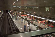
Muzeum is a Prague Metro station providing the interchange between Lines A and C, and serving the National Museum. It is located at the top end of Wenceslas Square.
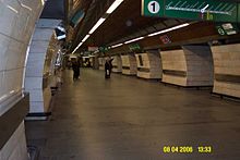
The Line C part was opened in 1974. It is a single hall station, 194 metres (636 ft) long and only 10 metres (33 ft) deep. Two escalators and a normal staircase go to the vestibule.
The Line A part was opened in 1978. It is a three-bore station with a shortened, 69-metre (226 ft) middle tunnel. It is 108 metres (354 ft) long and 34 metres (112 ft) deep. The station was damaged during the 2002 floods.
Nearby Attractions
External links
- http://www.angrenost.cz/metro/a/mu.php Gallery and information (English)
← direction Dejvická Prague Metro – line A direction Depo Hostivař → Můstek Muzeum Náměstí Míru Dejvická  – Hradčanská – Malostranská – Staroměstská – Můstek B – Muzeum C
  – Náměstí Míru – Jiřího z Poděbrad – Flora – Želivského – Strašnická
  – Skalka
  - Depo Hostivař
← direction Letňany Prague Metro – line C direction Háje → Hlavní nádraží Muzeum I. P. Pavlova Letňany  - Prosek
  - Střížkov
  - Ládví
  – Kobylisy
  – Nádraží Holešovice
  – Vltavská
  – Florenc B
  – Hlavní nádraží
  – Muzeum A
  – I. P. Pavlova – Vyšehrad
  – Pražského povstání – Pankrác
  – Budějovická
  – Kačerov – Roztyly
  – Chodov
  – Opatov
  – Háje

This Prague Metro-related article is a stub. You can help Wikipedia by expanding it. This article about a Czech railway station is a stub. You can help Wikipedia by expanding it.


