- Nacimiento River
-
Nacimiento River 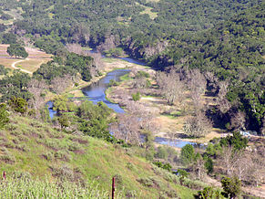 The river downstream of Nacimiento Dam
Country United States State California Tributaries - right Los Burros Creek, Las Tablas Creek Source Unnamed spring - location Santa Lucia Mountains, San Luis Obispo County - elevation 3,280 ft (1,000 m) - coordinates 36°01′55″N 121°28′21″W / 36.03194°N 121.4725°W [1] Mouth Salinas River - location Camp Roberts, Monterey County - elevation 584 ft (178 m) - coordinates 35°49′57″N 120°45′30″W / 35.8325°N 120.75833°W [1] Length 64.8 mi (104 km) Basin 350 sq mi (906 km2) Discharge for below Nacimiento Dam - average 272 cu ft/s (8 m3/s) [2] - max 7,340 cu ft/s (208 m3/s) - min 0 cu ft/s (0 m3/s)  Map of the Salinas River watershed including the Nacimiento River
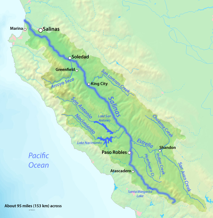
The Nacimiento River is a 64.8-mile-long (104.3 km)[3] river in southern Monterey County and northern San Luis Obispo County, California. A large portion of the river's run is on military reservations. The river's upper reaches are inside Fort Hunter Liggett, Lake Nacimiento is in the middle and the lower reaches are inside Camp Roberts.
Geography
Rising on the east side of the Santa Lucia Mountains, part of the Coast Ranges, the river travels southeast from its headwaters through generally hilly terrain. Further on, the Nacimiento Dam forms Lake Nacimiento, the largest in San Luis Obispo County. Downstream from the dam, the river travels east until it joins the Salinas River at Camp Roberts, Monterey County. The San Antonio River, which feeds Lake San Antonio and is also a Salinas River tributary, mirrors Nacimiento's path several miles to the northeast. The river provides water for irrigation and groundwater recharge. The lake is also a popular site for recreation, such as swimming, boating, fishing and water skiing.
See also
References
- ^ a b "Nacimiento River". Geographic Names Information System, U.S. Geological Survey. 1981-01-19. http://geonames.usgs.gov/pls/gnispublic/f?p=gnispq:3:::NO::P3_FID:272621. Retrieved 2011-05-03.
- ^ "USGS Gage #11149400 on the Nacimiento River below Nacimiento Dam, near Bradley, CA". National Water Information System. U.S. Geological Survey. 1958-present. http://wdr.water.usgs.gov/wy2009/pdfs/11149400.2009.pdf. Retrieved 2011-05-03.
- ^ U.S. Geological Survey. National Hydrography Dataset high-resolution flowline data. The National Map, accessed March 15, 2011
Categories:- Rivers of Monterey County, California
- Rivers of San Luis Obispo County, California
- Monterey Ranger District, Los Padres National Forest

Wikimedia Foundation. 2010.