Mariaparochie

Mariaparochie
Mariaparochie
—  Town  —
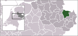
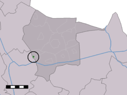
The town centre (dark green) and the statistical district (light green) of Mariaparochie in the municipality of Tubbergen.
Coordinates: 52°22′48″N 6°42′24″E / 52.38°N 6.70667°E / 52.38; 6.70667Coordinates: 52°22′48″N 6°42′24″E / 52.38°N 6.70667°E / 52.38; 6.70667
Country Netherlands
Province Overijssel
Municipality Almelo, Tubbergen
Population (2007)
 – Total 296
Time zone CET (UTC+1)
 – Summer (DST) CEST (UTC+2)
Postal code

Mariaparochie is a town in the Dutch province of Overijssel. It is a part of the municipality of Tubbergen, and lies about 4 km northeast of Almelo.

In 2001, the town of Mariaparochie had 281 inhabitants. The built-up area of the town was 0.069 km², and contained 95 residences.[1] The statistical area "Mariaparochie", which also can include the peripheral parts of the village, as well as the surrounding countryside, has a population of around 290.[2]

References

  1. ^ Statistics Netherlands (CBS), Bevolkingskernen in Nederland 2001. (Statistics are for the continuous built-up area).
  2. ^ Statistics Netherlands (CBS), Statline: Kerncijfers wijken en buurten 2003-2005. As of 1 January 2005.


Wikimedia Foundation. 2010.

Игры ⚽ Поможем сделать НИР

Look at other dictionaries:

  • Mariaparochie — 52°22′48″N 6°42′24″E / 52.38, 6.70667 …   Wikipédia en Français

  • Herman Finkers — Hermenegildus ( Herman ) Felix Victor Maria Finkers (born December 9 1954 in Almelo, Overijssel) is a comedian from the Dutch region of Twente, who became famous because for his dry witted humour and his ambiguous style of storytelling. He… …   Wikipedia

  • Tubbergen — Héraldique …   Wikipédia en Français

  • Oldenzaal railway station — Oldenzaal Station statistics Coordinates 52°18′22″N …   Wikipedia

  • Tubbergen — Infobox Settlement official name = Tubbergen mapsize = 280px subdivision type = Country subdivision name = Netherlands subdivision type1 = Province subdivision name1 = Overijssel area footnotes = (2006) area total km2 = 147.40 area land km2 = 146 …   Wikipedia

  • List of places in the Netherlands — This is an alphabetical list of places (cities, towns, villages) in the Netherlands. Lists per province can be found at:* List of towns in Groningen * List of towns in Friesland * List of towns in Drente * List of towns in Overijssel * List of… …   Wikipedia

  • Jan Stuyt — (21 August 1868, Purmerend 11 July 1934, The Hague) was a Dutch architect. Stuyt started his architectural career in 1883 at the office of A.C. Bleys (1842 1912), whose neo Romanesque style would become of great influence on Stuyt. In 1891 Stuyt… …   Wikipedia

  • Tubbergen — Gemeinde Tubbergen Flagge Wappen Provinz Overijssel Bürgermeister …   Deutsch Wikipedia

  • Aadorp — 52°22′43″N 6°37′38″E / 52.37861, 6.62722 …   Wikipédia en Français

  • Albergen — 52° 22′ 18″ N 6° 45′ 43″ E / 52.3717, 6.76194 …   Wikipédia en Français

Share the article and excerpts

Direct link
Do a right-click on the link above
and select “Copy Link”