Manderveen

Manderveen
Manderveen
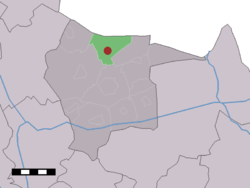
The village (dark red) and the statistical district (light green) of Manderveen in the municipality of Tubbergen.
Country Netherlands
Province Overijssel
Municipality Tubbergen
Population (2007) 640


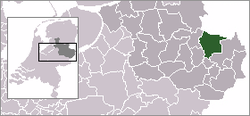
Manderveen (52°27′N 6°47′E / 52.45°N 6.783°E / 52.45; 6.783) is a town in the Dutch province of Overijssel. It is a part of the municipality of Tubbergen, and lies about 13 km northeast of Almelo.

The statistical area "Manderveen", which also can include the surrounding countryside, has a population of around 640.[1]

References

  1. ^ Statistics Netherlands (CBS), Statline: Kerncijfers wijken en buurten 2003-2005. As of 1 January 2005.


Wikimedia Foundation. 2010.

Игры ⚽ Нужен реферат?

Look at other dictionaries:

  • Manderveen — 52°26′44″N 6°46′42″E / 52.44556, 6.77833 …   Wikipédia en Français

  • Ryszard Zając — (* 6. Januar 1951 in Jelenia Góra) ist ein polnischer Künstler, der sowohl als Bildhauer als auch als Musiker tätig ist. Leben Ryszard Zając April 2009 Jelenia Góra Von 1965 bis 1968 besuchte Zając das Kunstgymnasium in Jelenia Góra. Dieses… …   Deutsch Wikipedia

  • Tubbergen — Héraldique …   Wikipédia en Français

  • Tubbergen — Infobox Settlement official name = Tubbergen mapsize = 280px subdivision type = Country subdivision name = Netherlands subdivision type1 = Province subdivision name1 = Overijssel area footnotes = (2006) area total km2 = 147.40 area land km2 = 146 …   Wikipedia

  • List of places in the Netherlands — This is an alphabetical list of places (cities, towns, villages) in the Netherlands. Lists per province can be found at:* List of towns in Groningen * List of towns in Friesland * List of towns in Drente * List of towns in Overijssel * List of… …   Wikipedia

  • Albergen — 52° 22′ 18″ N 6° 45′ 43″ E / 52.3717, 6.76194 …   Wikipédia en Français

  • Fleringen — 52°22′54″N 6°48′18″E / 52.38167, 6.805 …   Wikipédia en Français

  • Geesteren (Overijssel) — Geesteren Administration Pays  Pays Bas Province Overijssel Commune …   Wikipédia en Français

  • Haarle (Tubbergen) — 52°24′10″N 6°50′23″E / 52.40278, 6.83972 …   Wikipédia en Français

  • Harbrinkhoek — 52°23′7″N 6°43′3″E / 52.38528, 6.7175 …   Wikipédia en Français

Share the article and excerpts

Direct link
Do a right-click on the link above
and select “Copy Link”