- Arizona's 7th congressional district
Infobox U.S. congressional district
state = Arizona
district number = 7
image width = 300
image caption =
representative =Raúl Grijalva
party = Democratic
english area =22,891
metric area =
percent urban = 83.6
percent rural = 16.4
population = 641,329
population year = 2000
median income = 30,828
percent white = 38.6
percent black = 2.8
percent asian = 1.3
percent native american = 5.3
percent hispanic = 50.6
percent other race = 0.1
percent blue collar =
percent white collar =
percent gray collar =
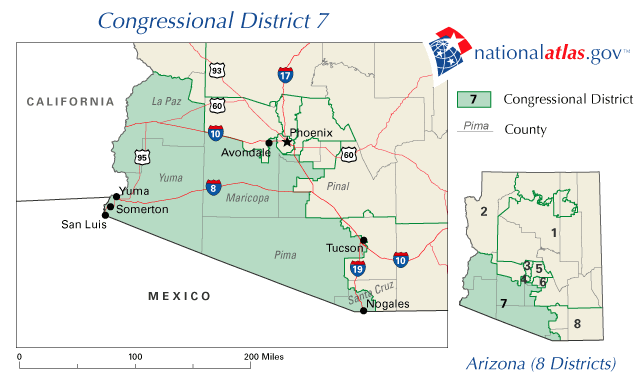
cpvi = D+10Arizona's 7th congressional district is located in the southwestern part of the state. It includes all of Yuma County, in addition to parts of La Paz, Maricopa, Pima, Pinal, and Santa Cruz counties. It is a Latino-majority district, with 50.6% of residents describing themselves as Hispanic (as of the 2000 census).
It is currently represented by
Raúl M. Grijalva , a Democrat.George W. Bush received 43% of the vote in this district in 2004.Statistics
* Male 49.7%, Female 50.3%
* Median age: 30.8Competitiveness
The high Latino and Native American populations in this district tend to favor Democrats to a large extent. There are some Anglo pockets around
Yuma and in the Phoenix Metropolitan area, but not enough to be a factor in congressional races in this district for the near future.Election results
The district was created in time for the 2002 elections.
2002
Historical representation
Geography
*Arizona Congressional District 7 is larger than Rhode Island, Delaware, Hawaii, Connecticut and New Jersey combined. [http://www.house.gov/grijalva/district.html]
*The district includes 300 miles of the United States' border with Mexico.
*The district is home to seven sovereign Native American nations: theAk-Chin Indian Community ,Cocopah ,Colorado River Indian Tribes ,Gila River Indian Community ,Pascua Yaqui Tribe ,Quechan , andTohono O'odham .References
# [http://fastfacts.census.gov/servlet/CWSFacts?_event=ChangeGeoContext&geo_id=50000US0405&_geoContext=01000US%7C04000US04%7C50000US0404&_street=&_county=&_cd=50000US0405&_cityTown=&_state=04000US04&_zip=&_lang=en&_sse=on&ActiveGeoDiv=&_useEV=&pctxt=fph&pgsl=500&_content=&_keyword=&_industry= Demographic information at census.gov]
# [http://www.cnn.com/ELECTION/2004//pages/results/states/AZ/index.html 2004 Election data at CNN.com]
# [http://www.election.cbsnews.com/campaign2002/state/state_az.shtml 2002 Election data from CBSNews.com]
Wikimedia Foundation. 2010.
