- Deurze
-
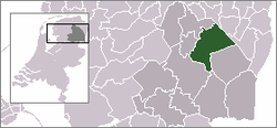
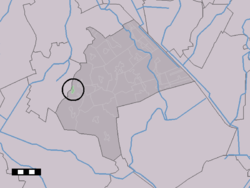
Deurze — Town — Deurze in the municipality of Aa en Hunze. Coordinates: 52°59′1″N 6°36′33″E / 52.98361°N 6.60917°ECoordinates: 52°59′1″N 6°36′33″E / 52.98361°N 6.60917°E Country Netherlands Province Drenthe Municipality Aa en Hunze Population (1 January 2008) – Total 82 Time zone CET (UTC+1) – Summer (DST) CEST (UTC+2) Postal code Deurze is a town in the Dutch province of Drenthe. It is a part of the municipality of Aa en Hunze, and lies about 4 km southeast of Assen.
The statistical area "Deurze", which also can include the surrounding countryside, has a population of around 90.[1]
Transportation
There is no station here. The nearest station is Assen railway station. The nearest bus stop is about 1 km north of the centre at which services 10, 21, 24 and 28 stop.
For further information see Aa en Hunze#Transportation.
References
- ^ Statistics Netherlands (CBS), Statline: Kerncijfers wijken en buurten 2003-2005. As of 1 January 2005.
Villages: Amen | Anderen | Anloo | Annen | Annerveenschekanaal | Balloo | Deurze | Eext | Eexterveen | Eexterveenschekanaal | Ekehaar | Eldersloo | Gasselte | Gasselternijveen | Gasselternijveenschemond | Gasteren | Gieten | Gieterveen | Grolloo | Nieuw-Annerveen | Nieuwediep | Nijlande | Oud-Annerveen | Rolde | Schipborg | Schoonloo | Spijkerboor
Hamlets: Achter 't Hout | Balloërveld | Bareveld | Bonnen | Bonnerveen | Bosje | Broek | Cortenoever | De Hilte | Eleveld | Gasselterboerveen | Gasselterboerveenschemond | Gasselternijveenschemond-Eerste Dwarsdiep | Gasselternijveenschemond-Tweede Dwarsdiep | Geelbroek | Gieterzandvoort | Kostvlies | Marwijksoord | Nooitgedacht | Papenvoort | Veenhof | Vredenheim
Categories:- Populated places in Drenthe
- Drenthe geography stubs
Wikimedia Foundation. 2010.


