- Drijber
-
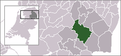
Drijber — Town — The village (dark red) and the statistical district (light green) of Drijber in the municipality of Midden-Drenthe. Coordinates: 52°47′30″N 6°32′14″E / 52.79167°N 6.53722°ECoordinates: 52°47′30″N 6°32′14″E / 52.79167°N 6.53722°E Country Netherlands Province Drenthe Municipality Midden-Drenthe Population (1 January 2004) – Total 120 Time zone CET (UTC+1) – Summer (DST) CEST (UTC+2) Postal code 9437 Dialing code 0593 Drijber is a town in the Dutch province of Drenthe. It is a part of the municipality of Midden-Drenthe, and lies about 9 km north of Hoogeveen.
The statistical area "Drijber", which also can include the surrounding countryside, has a population of around 480.[1]
References
- ^ Statistics Netherlands (CBS), Statline: Kerncijfers wijken en buurten 2003-2005. As of 1 January 2005.
Villages Balinge - Beilen - Bovensmilde - Brunsting - Bruntinge - Drijber - Elp - Eursinge - Garminge - Hijken - Hijkersmilde - Holthe - Hoogersmilde - Hooghalen - Laaghalen - Laaghalerveen - Lieving - Makkum - Mantinge - Nieuw-Balinge - Oranje (Drenthe) - Orvelte - Smalbroek - Smilde - Spier - Ter Horst - Westerbork - Wijster - Witteveen - Zuidveld - ZwiggelteCategories:- Populated places in Drenthe
- Drenthe geography stubs
Wikimedia Foundation. 2010.


