- Outlane
-
Coordinates: 53°39′28″N 1°52′21″W / 53.657812°N 1.872496°W
Outlane 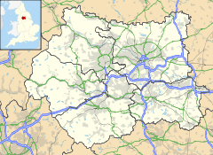
 Outlane
Outlane shown within West YorkshirePopulation 710 (2001 Census) OS grid reference SE085179 Metropolitan borough Kirklees Metropolitan county West Yorkshire Region Yorkshire and the Humber Country England Sovereign state United Kingdom Post town HUDDERSFIELD Postcode district HD3 Dialling code 01422 Police West Yorkshire Fire West Yorkshire Ambulance Yorkshire EU Parliament Yorkshire and the Humber UK Parliament Colne Valley List of places: UK • England • Yorkshire
Outlane is a village near Huddersfield, West Yorkshire, England with a population of 710 according to the 2001 census. It is situated 3.7 miles (6.0 km) north-west of the Huddersfield town centreIt is situated next to the M62 Motorway (near junction 23) and it is very close to the Calderdale and Kirklees district boundary.
Outlane's cricket club objected to the building of the motorway in the 1960s as it would go through their ground. However the Ministry Of Transport turned it down.
Outlane has a golf course that also borders the motorway.
Outlane is also the location of a Roman fort, also known as Slack, Roman name possibly Cambodunum
External links
Categories:- West Yorkshire geography stubs
- Geography of Huddersfield

Wikimedia Foundation. 2010.