- Mount Gahinga
-
Mount Gahinga 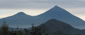
Mts. Gahinga (left) and Muhabura (right)Elevation 3,474 m (11,398 ft) Prominence 2,821 m (9,255 ft) Translation A little pile of stones (Kinyarwanda) Location Location Rwanda–Uganda Range Virunga Mountains Coordinates 1°23′14″S 29°38′37″E / 1.3873°S 29.6435°ECoordinates: 1°23′14″S 29°38′37″E / 1.3873°S 29.6435°E Geology Type Stratovolcano Last eruption unknown Climbing Easiest route Hike Mount Gahinga, is a dormant/extinct volcano in the Virunga Mountains on the border between Rwanda and Uganda. Gahinga lies between Muhabura and Sabyinyo, but is the smallest of these three. The Mgahinga Gorilla National Park is named after the mountain, and tourists can climb Gahinga from that side.
Categories:- Stratovolcanoes
- Virunga Mountains
- Volcanoes of Rwanda
- Mountains of Rwanda
- Rwanda–Uganda border
- Mountains of Uganda
- International mountains of Africa
- Rwanda geography stubs
- Uganda geography stubs

Wikimedia Foundation. 2010.